Mapping and cartography
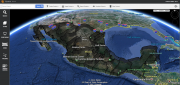
THE INSIDE STORY: Google Earth Enterprise Goes Open Source
August 4, 2017
On March 20, 2015, Google deprecated Google Earth Enterprise (GEE), which had contributed greatly to the market for geospatial...
August 4, 2017
On March 20, 2015, Google deprecated Google Earth Enterprise (GEE), which had contributed greatly to the market for geospatial...

FINAL ARTICLE IN THE SERIES on Geospatial Processing & Visualization: Ubisense and Harris Geospatial Solutions
August 4, 2017
The line between vendors of geospatial software and providers of geospatial data is increasingly blurred, as more companies...
August 4, 2017
The line between vendors of geospatial software and providers of geospatial data is increasingly blurred, as more companies...
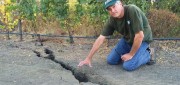
Shifting Ground: USGS on Earth Movement after an Earthquake
June 29, 2017
Ken Hudnut, science advisor for risk reduction, US Geological Survey, talks GPS and earthquakes Editor’s note: In many...
June 29, 2017
Ken Hudnut, science advisor for risk reduction, US Geological Survey, talks GPS and earthquakes Editor’s note: In many...
The iCon build: Adding Adaptable Options for Layout Automation
June 29, 2017
At CONEXPO 2017, we were given a demonstration of one tool in the new wave of automated layout solutions for vertical...
June 29, 2017
At CONEXPO 2017, we were given a demonstration of one tool in the new wave of automated layout solutions for vertical...
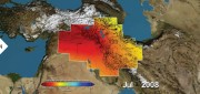
Satellite Missions Improve Water Estimates
April 28, 2017
Fresh water is humanity’s single most critical resource. According to a recent United Nations report, stresses on water...
April 28, 2017
Fresh water is humanity’s single most critical resource. According to a recent United Nations report, stresses on water...

Cadasta: Mapping Land Rights from the Bottom Up
April 12, 2017
Cadasta helps put people on the map with a cloud-based platform for land-ownership data. In advanced industrial countries...
April 12, 2017
Cadasta helps put people on the map with a cloud-based platform for land-ownership data. In advanced industrial countries...
Building “Digital Earth”
February 23, 2017
A new generation of geospatial intelligence helps to answer complex geographic questions Paper maps obsolesce rapidly from...
February 23, 2017
A new generation of geospatial intelligence helps to answer complex geographic questions Paper maps obsolesce rapidly from...

LIDAR Is Key To Autonomous Vehicles
February 23, 2017
Technology for autonomous vehicles builds on car navigation systems that have been commonplace for years and new collision-avoidance...
February 23, 2017
Technology for autonomous vehicles builds on car navigation systems that have been commonplace for years and new collision-avoidance...
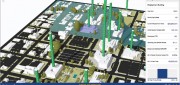
A State Gets Smart: SmarterBetterCities
February 21, 2017
To help formulate a 10-year strategic capital investment plan for the State of Oregon, the state’s Chief Financial Office...
February 21, 2017
To help formulate a 10-year strategic capital investment plan for the State of Oregon, the state’s Chief Financial Office...

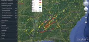
Mapping the Appalachian Trail (Part 2 of 2)
February 21, 2017
In 1998, the Appalachian Trail Conservancy (ATC) began its GIS program. Its first two challenges were to map the trail’s...
February 21, 2017
In 1998, the Appalachian Trail Conservancy (ATC) began its GIS program. Its first two challenges were to map the trail’s...