Sensors

Blending Realities
November 11, 2015
Imagine designing an object, in 3D and color, using only gaze, gestures, and voice (GGV) commands. Imagine designing an entire...
November 11, 2015
Imagine designing an object, in 3D and color, using only gaze, gestures, and voice (GGV) commands. Imagine designing an entire...
Sensor Fusion: Deriving Information from Data
April 9, 2015
The current explosion in the variety, capability and sheer number of sensors is generating a flood of data intended to enhance...
April 9, 2015
The current explosion in the variety, capability and sheer number of sensors is generating a flood of data intended to enhance...

Real-Time Monitoring A Hit Down Under
January 11, 2015
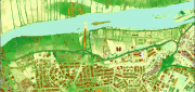
In the heart of Brisbane, Australia’s third most populous city, constructioncompany Watpac Australia Pty. Ltd. has a contract...
January 11, 2015
In the heart of Brisbane, Australia’s third most populous city, constructioncompany Watpac Australia Pty. Ltd. has a contract...

Monitoring Polar Changes: Scientists Deploy Many Tools to Measure Sea Ice Thickness
December 29, 2014
The extent of the polar ice caps is shrinking. This simple fact has been common knowledge since the late 1970s thanks to the added...
December 29, 2014
The extent of the polar ice caps is shrinking. This simple fact has been common knowledge since the late 1970s thanks to the added...
Mobile System Alerts Dubai Drivers of Approaching Sandstorms
October 16, 2014
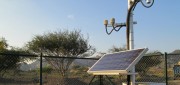
Periodically, large sandstorms and low-visibility conditions wreak havoc in the Middle East, with potentially deadly consequences...
October 16, 2014
Periodically, large sandstorms and low-visibility conditions wreak havoc in the Middle East, with potentially deadly consequences...

UNEP Takes Advantage of Today’s Technology for Better and Cheaper Monitoring
May 28, 2014
The United Nations Environment Program is responsible for assisting countries in the collection of environmental data for more...
May 28, 2014
The United Nations Environment Program is responsible for assisting countries in the collection of environmental data for more...
The Abyss, Now Live on Your Desktop
August 5, 2013
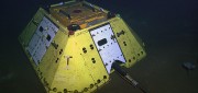
The advent of Earth-observation satellites transformed how we view our planet—from occasional snapshots to near continuous,...
August 5, 2013
The advent of Earth-observation satellites transformed how we view our planet—from occasional snapshots to near continuous,...
Sensing the Forest for Fuel, Fire, and Recovery
May 6, 2013
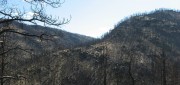
Every year, several hundred million hectares of forest, grasslands, and other types of vegetation burn throughout the world,...
May 6, 2013
Every year, several hundred million hectares of forest, grasslands, and other types of vegetation burn throughout the world,...

Biosensors for Environmental Monitoring
July 31, 2012
The idea for biosensors — using some part of an organism to generate a signal to measure or monitor the presence of a substance...
July 31, 2012
The idea for biosensors — using some part of an organism to generate a signal to measure or monitor the presence of a substance...
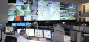
Traffic Data Hits on Real-Time Needs
June 25, 2012
For decades, state and local departments of transportation have collected traffic data by means of a variety of methods — including...
June 25, 2012
For decades, state and local departments of transportation have collected traffic data by means of a variety of methods — including...