LiDAR

A Lidar That Oversamples: Geiger Lidar Imaging
October 10, 2016
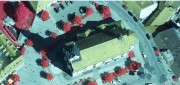
Typical linear lidar systems repeatedly fire a single beam, each time measuring a single location on the ground. They collect...
October 10, 2016
Typical linear lidar systems repeatedly fire a single beam, each time measuring a single location on the ground. They collect...

Geospatial Solutions: from PIXIA, Luciad, and BAE Systems
October 10, 2016
This series began a year ago by examining alternatives to Google Earth Enterprise, which Google will stop supporting on March...
October 10, 2016
This series began a year ago by examining alternatives to Google Earth Enterprise, which Google will stop supporting on March...
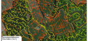
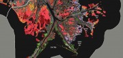
LiDAR, GIS and the Chesapeake Conservancy: Precision Conservation
June 2, 2016
Building on the practice of precision agriculture and exploiting recent computer advances, the Chesapeake Conservancy (CC)...
June 2, 2016
Building on the practice of precision agriculture and exploiting recent computer advances, the Chesapeake Conservancy (CC)...
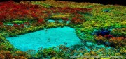
Wetlands Worth their Weight
March 2, 2016
"Wetland" is a generic term covering a wide variety of habitats that are wet for at least some period of time each year,...
March 2, 2016
"Wetland" is a generic term covering a wide variety of habitats that are wet for at least some period of time each year,...

Oregon Preparing for Export: Assessing the Seismic Challenges of a Liquified Natural Gas Plant
December 3, 2015
In the international port of Coos Bay, Ore., construction will begin in late 2016 on a liquefied natural gas (LNG) export...
December 3, 2015
In the international port of Coos Bay, Ore., construction will begin in late 2016 on a liquefied natural gas (LNG) export...
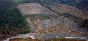
See the Light: LiDAR Data Help Expose Landslide Hazards
October 12, 2015
On March 22, 2014, four miles east of Oso, Wash., a portion of an unstable hill collapsed, sending mud and debris across...
October 12, 2015
On March 22, 2014, four miles east of Oso, Wash., a portion of an unstable hill collapsed, sending mud and debris across...

Real-Time Monitoring A Hit Down Under
January 11, 2015
In the heart of Brisbane, Australia’s third most populous city, constructioncompany Watpac Australia Pty. Ltd. has a contract...
January 11, 2015
In the heart of Brisbane, Australia’s third most populous city, constructioncompany Watpac Australia Pty. Ltd. has a contract...

Monitoring Polar Changes: Scientists Deploy Many Tools to Measure Sea Ice Thickness
December 29, 2014
The extent of the polar ice caps is shrinking. This simple fact has been common knowledge since the late 1970s thanks to the added...
December 29, 2014
The extent of the polar ice caps is shrinking. This simple fact has been common knowledge since the late 1970s thanks to the added...
Improving Global Carbon Estimates with LiDAR
May 13, 2014
International efforts to mitigate climate change hinge on limiting global anthropogenic CO2 emissions. About 12 percent of these...
May 13, 2014
International efforts to mitigate climate change hinge on limiting global anthropogenic CO2 emissions. About 12 percent of these...
Lidar Innovations: Software Catching Up, Alternative Technologies Emerge
February 24, 2014
Throughout its history, lidar has been one of the very few technologies in which the exponential growth in the hardware’s...
February 24, 2014
Throughout its history, lidar has been one of the very few technologies in which the exponential growth in the hardware’s...