LiDAR
Surveying Cultural Heritage
December 6, 2013
CyArk, a nonprofit organization dedicated to digitally preserving and sharing the world’s cultural heritage, uses laser...
December 6, 2013
CyArk, a nonprofit organization dedicated to digitally preserving and sharing the world’s cultural heritage, uses laser...

Measuring Distant Winds: Remote Sensing for Siting Wind Turbines
July 8, 2013
Wind's contribution to energy production in the United States continues to grow. In 2011, it represented a third of all new electric...
July 8, 2013
Wind's contribution to energy production in the United States continues to grow. In 2011, it represented a third of all new electric...
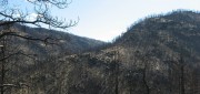
Sensing the Forest for Fuel, Fire, and Recovery
May 6, 2013
Every year, several hundred million hectares of forest, grasslands, and other types of vegetation burn throughout the world,...
May 6, 2013
Every year, several hundred million hectares of forest, grasslands, and other types of vegetation burn throughout the world,...
Bathymetric LiDAR: Sandy’s Coastal Impact
February 11, 2013
Detailed and accurate charting of the sea bottom along coastlines is vital for environmental monitoring and remediation,...
February 11, 2013
Detailed and accurate charting of the sea bottom along coastlines is vital for environmental monitoring and remediation,...

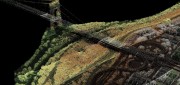
The Oregon Lidar Consortium
January 4, 2013
In less than six years since it was formed, the Oregon Lidar Consortium (OLC) has collected 16 million acres of high-resolution...
January 4, 2013
In less than six years since it was formed, the Oregon Lidar Consortium (OLC) has collected 16 million acres of high-resolution...

Mark Romano: Earth Eye Makes Inroads in Sensor Fusion
November 5, 2012
Earth Eye is a relatively new company that has been focused on LiDAR data capture, and the fusion of LiDAR with other sensor...
November 5, 2012
Earth Eye is a relatively new company that has been focused on LiDAR data capture, and the fusion of LiDAR with other sensor...

LiDAR Software Update: Companies Respond to Customer Demands
February 25, 2012
The market for software to manage, process, fuse, and visualize LiDAR point cloud data is still very young and amorphous....
February 25, 2012
The market for software to manage, process, fuse, and visualize LiDAR point cloud data is still very young and amorphous....
Processing Point Clouds: 3D Data Update
October 25, 2011
Like raster and vector data many years ago, 3D clouds of billions of LiDAR points — which can be colored and very realistic...
October 25, 2011
Like raster and vector data many years ago, 3D clouds of billions of LiDAR points — which can be colored and very realistic...
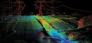
LiDAR Update: Terrestrial Explodes, Software Still Lags
January 25, 2011
Looking at the image of the underside of a bridge derived from data collected by a boat-mounted LiDAR system, engineers can detect...
January 25, 2011
Looking at the image of the underside of a bridge derived from data collected by a boat-mounted LiDAR system, engineers can detect...
Helping Haiti: Disaster-Response Lab Manages Aerial Data for Earthquake Relief
October 1, 2010
In the immediate aftermath of the devastating earthquake that hit Haiti on 2010 January 12, taking the lives of more than...
October 1, 2010
In the immediate aftermath of the devastating earthquake that hit Haiti on 2010 January 12, taking the lives of more than...