Feature articles
Receiver innovators log trends and product launches — Part 2
October 1, 2020
In the second part of our receiver feature, top receiver manufacturers discuss what’s on the horizon for GNSS receivers:...
October 1, 2020
In the second part of our receiver feature, top receiver manufacturers discuss what’s on the horizon for GNSS receivers:...

Research Roundup: Focus on maritime
October 1, 2020
Of the 273 papers researchers presented this year at the Institute of Navigation’s annual ION GNSS+ conference, which took...
October 1, 2020
Of the 273 papers researchers presented this year at the Institute of Navigation’s annual ION GNSS+ conference, which took...

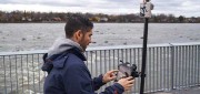
Access denied: Anti-jam technology mitigates navigation warfare threats
October 1, 2020
GPS signals are by far the single most widely used and most accurate source of navigation, positioning and timing (PNT),...
October 1, 2020
GPS signals are by far the single most widely used and most accurate source of navigation, positioning and timing (PNT),...

Soft information for IoT positioning
October 1, 2020
The billions of interconnected devices and sensors embedded in other devices, vehicles and even humans that collectively...
October 1, 2020
The billions of interconnected devices and sensors embedded in other devices, vehicles and even humans that collectively...
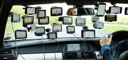
NAVIGATING TESTING OPTIONS: Simulator Innovators Map Out Solutions & Trends
September 24, 2020
The number of GNSS signals, the frequency and sophistication of intentional and unintentional threats to those signals,...
September 24, 2020
The number of GNSS signals, the frequency and sophistication of intentional and unintentional threats to those signals,...
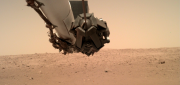
NASA’s Eyes on Mars
September 27, 2019
An old imaging technology is outdated for use on Earth, but it’s the perfect fit for today’s remote-sensing needs on Mars. Since...
September 27, 2019
An old imaging technology is outdated for use on Earth, but it’s the perfect fit for today’s remote-sensing needs on Mars. Since...
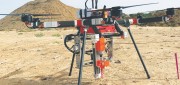
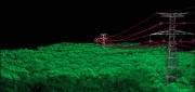
UAV Stakes Out New Ground
September 27, 2019
A flying/staking robot has taken a huge step forward in automation for site layout, including road, rail, utilities, and energy...
September 27, 2019
A flying/staking robot has taken a huge step forward in automation for site layout, including road, rail, utilities, and energy...
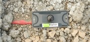
RFID Crazy: RFID-enabled infrastructure marking could become a cornerstone for a connected infrastructure management world.
March 19, 2019
Imagine if all public works engineers and utility company crew chiefs were equipped with a mobile device that could easily...
March 19, 2019
Imagine if all public works engineers and utility company crew chiefs were equipped with a mobile device that could easily...

Aerial Self-sufficiency
March 5, 2019
A large risk-assessment and data-analytics company created its own internal system to collect imagery, write software, and develop...
March 5, 2019
A large risk-assessment and data-analytics company created its own internal system to collect imagery, write software, and develop...
Standalone UAV Lidar
March 5, 2019
A surveying company developed a self-contained UAV lidar system so teams could gather data without a lidar specialist. Some...
March 5, 2019
A surveying company developed a self-contained UAV lidar system so teams could gather data without a lidar specialist. Some...