UAS
Lidar Innovations: Software Catching Up, Alternative Technologies Emerge
February 24, 2014
Throughout its history, lidar has been one of the very few technologies in which the exponential growth in the hardware’s...
February 24, 2014
Throughout its history, lidar has been one of the very few technologies in which the exponential growth in the hardware’s...
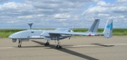
UAS Industry Poised for Explosion
October 24, 2012
Unmanned aerial systems (UAS, formerly called unmanned aerial vehicles), which the U.S. military has routinely used abroad...
October 24, 2012
Unmanned aerial systems (UAS, formerly called unmanned aerial vehicles), which the U.S. military has routinely used abroad...
Remote Sensing by Remote Control: UAVs Become Invaluable Assets
October 1, 2009
When Somali pirates hijacked the U.S. freighter Maersk Alabama and took Capt. Richard Phillips hostage in April, a U.S. Navy...
October 1, 2009
When Somali pirates hijacked the U.S. freighter Maersk Alabama and took Capt. Richard Phillips hostage in April, a U.S. Navy...