Imaging Notes
LiDAR Update: Terrestrial Explodes, Software Still Lags
January 25, 2011
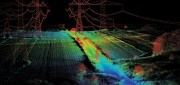
Looking at the image of the underside of a bridge derived from data collected by a boat-mounted LiDAR system, engineers can detect...
January 25, 2011
Looking at the image of the underside of a bridge derived from data collected by a boat-mounted LiDAR system, engineers can detect...
Aerial Cameras: Focus Shifts to Productivity
October 1, 2010
Every aerial or satellite image you see on Google Earth, on The Weather Channel, or in the pages of this magazine was taken...
October 1, 2010
Every aerial or satellite image you see on Google Earth, on The Weather Channel, or in the pages of this magazine was taken...
RADAR Gets It Done
June 1, 2010
Has anyone driven over certain desert dunes in Afghanistan during the past few hours? Is a ship on the high seas fishing...
June 1, 2010
Has anyone driven over certain desert dunes in Afghanistan during the past few hours? Is a ship on the high seas fishing...

Joel Campbell: Harnessing the Information of our Changing Earth (and Industry)
June 1, 2010
With over 20 years of experience in the geospatial industry, Joel Campbell is a well known and highly regarded speaker, lecturer...
June 1, 2010
With over 20 years of experience in the geospatial industry, Joel Campbell is a well known and highly regarded speaker, lecturer...

Beyond Terrain Models: LiDAR Enters the Geospatial Mainstream
February 1, 2010
First used by NASA in the mid-1980s, light detection and ranging (LiDAR) has become an essential complement to photogrammetry...
February 1, 2010
First used by NASA in the mid-1980s, light detection and ranging (LiDAR) has become an essential complement to photogrammetry...

Remote Sensing by Remote Control: UAVs Become Invaluable Assets
October 1, 2009
When Somali pirates hijacked the U.S. freighter Maersk Alabama and took Capt. Richard Phillips hostage in April, a U.S. Navy...
October 1, 2009
When Somali pirates hijacked the U.S. freighter Maersk Alabama and took Capt. Richard Phillips hostage in April, a U.S. Navy...