Aerial photography

Geospatial Solutions: from PIXIA, Luciad, and BAE Systems
October 10, 2016
This series began a year ago by examining alternatives to Google Earth Enterprise, which Google will stop supporting on March...
October 10, 2016
This series began a year ago by examining alternatives to Google Earth Enterprise, which Google will stop supporting on March...
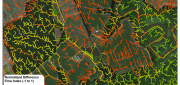
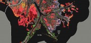
LiDAR, GIS and the Chesapeake Conservancy: Precision Conservation
June 2, 2016
Building on the practice of precision agriculture and exploiting recent computer advances, the Chesapeake Conservancy (CC)...
June 2, 2016
Building on the practice of precision agriculture and exploiting recent computer advances, the Chesapeake Conservancy (CC)...
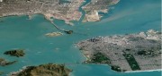
Companies Pick Up Where Google Earth Enterprise Leaves off
May 16, 2016
The waves created by Google’s announcement that it will stop supporting Google Earth Enterprise (GEE) in the spring of 2017...
May 16, 2016
The waves created by Google’s announcement that it will stop supporting Google Earth Enterprise (GEE) in the spring of 2017...
Wetlands Worth their Weight
March 2, 2016
"Wetland" is a generic term covering a wide variety of habitats that are wet for at least some period of time each year,...
March 2, 2016
"Wetland" is a generic term covering a wide variety of habitats that are wet for at least some period of time each year,...
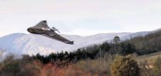
Trimble UAS Answers Tall Task
November 9, 2015
In the steep canyons of the Republic of Macedonia — a landlocked Balkan nation of mountains, lakes and ancient towns — international...
November 9, 2015
In the steep canyons of the Republic of Macedonia — a landlocked Balkan nation of mountains, lakes and ancient towns — international...
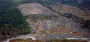
See the Light: LiDAR Data Help Expose Landslide Hazards
October 12, 2015
On March 22, 2014, four miles east of Oso, Wash., a portion of an unstable hill collapsed, sending mud and debris across...
October 12, 2015
On March 22, 2014, four miles east of Oso, Wash., a portion of an unstable hill collapsed, sending mud and debris across...

Moving Forward with UAS Mapping
June 16, 2015
For geospatial professionals, the most exciting aspect of the current explosion in unmanned aircraft systems (UASs) is using...
June 16, 2015
For geospatial professionals, the most exciting aspect of the current explosion in unmanned aircraft systems (UASs) is using...

Satellite Imagery’s Impact
April 10, 2015
Unthreatened, aerial imaging/mapping companies embrace commercial satellite imagery's increased resolution Last June,...
April 10, 2015
Unthreatened, aerial imaging/mapping companies embrace commercial satellite imagery's increased resolution Last June,...
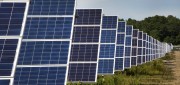
Maximizing the Sun: Solar energy grows in part due to aerial imaging and surveying
April 10, 2015
Solar power is booming in the United States. “Every three weeks,” President Obama said in his 2015 State of the Union...
April 10, 2015
Solar power is booming in the United States. “Every three weeks,” President Obama said in his 2015 State of the Union...

Developing the Map of the Future
April 9, 2015
Geospatial technology is changing. Now geographic information system (GIS) software is ingesting, organizing and visualizing...
April 9, 2015
Geospatial technology is changing. Now geographic information system (GIS) software is ingesting, organizing and visualizing...