Environment
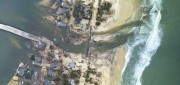
Mapping the Damage from Superstorm Sandy
July 22, 2013
When it hit the United States as a post-tropical cyclone, Sandy had a diameter of 1,100 miles and had been the largest Atlantic...
July 22, 2013
When it hit the United States as a post-tropical cyclone, Sandy had a diameter of 1,100 miles and had been the largest Atlantic...
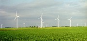
Measuring Distant Winds: Remote Sensing for Siting Wind Turbines
July 8, 2013
Wind's contribution to energy production in the United States continues to grow. In 2011, it represented a third of all new electric...
July 8, 2013
Wind's contribution to energy production in the United States continues to grow. In 2011, it represented a third of all new electric...
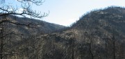
Sensing the Forest for Fuel, Fire, and Recovery
May 6, 2013
Every year, several hundred million hectares of forest, grasslands, and other types of vegetation burn throughout the world,...
May 6, 2013
Every year, several hundred million hectares of forest, grasslands, and other types of vegetation burn throughout the world,...

Spreading the Inspiration of Earth Observation
April 8, 2013
Research scientists continue to add to our understanding of Earth systems, thanks to the global Earth observation capacity....
April 8, 2013
Research scientists continue to add to our understanding of Earth systems, thanks to the global Earth observation capacity....