3D Software, Not Really Like CAD at All
Editor’s note: For many firms and practitioners of surveying, photogrammetry, mapping, and remote sensing, traditional deliverables to AEC clients have focused on the civil-design, full-on-CAD track. For planning and evaluation of design alternatives, something new–more fit for purpose–was needed to fit that niche, something between full-civil-design CAD and 2D schematic GIS, with less operational overhead than the former, yet richer and more versatile than the latter, and in full 3D. Here we describe prominent software designed specifically to meet those needs. Traditionally, architectural and engineering projects begin as sketches, are then designed in detail in CAD, and then translated into visualizations that are much more accessible to non-technical clients and stakeholders. Autodesk’s InfraWorks 360 3D design and communication platform eliminates these costly and time-consuming steps by enabling EAC professionals to run projects from beginning to end in a single environment.
One solution available in the market is Autodesk’s InfraWorks 360 3D design and communication platform. The software is particularly adept at answering “What if?” questions by quickly building a model and displaying its context.
“With traditional CAD,” says Eric Chappell, Autodesk’s community evangelist for the program,
“you would have to take what you see on the screen and re-work it into something that made sense to a client or a city council. When you are working in InfraWorks 360, it is already there.”
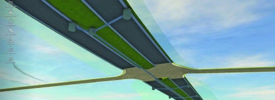
Tools in the program enable users to build a context “pretty much out of thin air,” says Chappell, and then let them design in more detail roads, grading, buildings, bridges, water features, etc. Users can evaluate those designs with their clients and community partners, explore whether they work from an engineering standpoint and meet zoning requirements, and explore multiple alternatives for a project. For example, where two roads cross, is the best solution a standard intersection, a round-about, or a bridge? Users can explore several options in a few minutes, even with a client, and make big decisions early on, before construction begins. They can use tools in the software to keep multiple stakeholders informed and to collaborate with a virtual team working on an InfraWorks model from anywhere on the planet.