Custom, Portable Maps — Via App!
Avenza has evolved its map products into an app that lets people upload their own map—or download a map of their choice—to their mobile devices, and customize it.
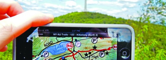
Whether for fighting a wildland fire, delivering packages, or exploring tourist sites, using a map should be easy and quick. Well, especially when you’re fighting a fire that’s moving at seven miles an hour!
The transition from static, analog paper maps (that are already obsolete the moment they leave the print shop) to digital, interactive maps on our mobile devices has dramatically increased maps’ usefulness. However, global maps for general use–such as Google Maps, Bing maps, Apple Maps, and OpenStreetMap–do not display many of the features displayed by maps produced for specific uses, such as topographic maps for hikers, bathymetric charts for mariners, or cadastral maps for surveyors, city planners, and tax collectors.
Avenza Maps, a mobile application by Avenza Systems, makes it easy for users to display on a mobile device the most appropriate map for their particular application while also taking advantage of the device’s GPS receiver to mark their position on the map. Users can download maps from Avenza’s very large map library or create their own and open them in the application.