Trimble UAS Answers Tall Task
In the steep canyons of the Republic of Macedonia — a landlocked Balkan nation of mountains, lakes and ancient towns — international construction company AKTOR ADT is completing a major highway project for the national government. The highway will run 28.2 kilometers or 17.5 miles from the village of Demir Kapija to Smokvica, traversing a natural gorge and crossing the Vardar River. It will help complete the most important north-south route through the country, Corridor X, which provides a connection to the region’s modern, multinational transport network. Due to the area’s challenging geomorphology — including steep slopes, ravines, rivers, forests and protected areas — the survey project was designed and is being undertaken with great regard for the environmental conditions and protection of the local flora and fauna.
The effort, which began in March 2013 and is projected to continue through the end of 2016, requires construction of millions of cubic meters of earthworks, as well as many heavy structures. The project includes two twin tunnels, six bridges (four of which are balanced cantilever bridges), five overpasses, seven underpasses, two interchanges, 100-plus culverts, high embankments and deep cuts. As a result, the work requires regular monitoring of the amount of material removed, landslides after heavy rain falls and other such variables, as well as progress reporting to the government ministries.
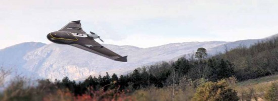
To conduct the survey, the Athens, Greece-based AKTOR ADT has contracted with AVIATOP pc, a company it has collaborated with for many years. AVIATOP deploys various unmanned aircraft systems (UAS) to provide aerial mapping and surveying services for corridor mapping and monitoring the progress of construction projects. For this project, the company is using a Trimble UX5 to fly over the project corridor and collect data every two months for the entire project timeline. Equipped with a high-resolution camera, the UX5 captures images needed to measure the slope edges of cuts and fills, and the surface of the roadway. George Papastamos, a surveying engineer and AVIATOP’s founder and CEO, is the lead on the project.