Geospatial topics
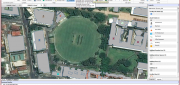
Companies Pick Up Where Google Earth Enterprise Leaves off
May 16, 2016
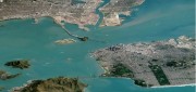
The waves created by Google’s announcement that it will stop supporting Google Earth Enterprise (GEE) in the spring of 2017...
May 16, 2016
The waves created by Google’s announcement that it will stop supporting Google Earth Enterprise (GEE) in the spring of 2017...

Data Management & Visualization: Married Or Separated?
March 21, 2016
Large users of geospatial data are searching for alternatives to Google Earth Enterprise (GEE), which Google will discontinue...
March 21, 2016
Large users of geospatial data are searching for alternatives to Google Earth Enterprise (GEE), which Google will discontinue...
Satellite Imagery for Precision Agriculture
March 13, 2016
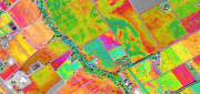
Precision agriculture consists primarily of using geospatial technologies to map spatial variations in crop and soil conditions...
March 13, 2016
Precision agriculture consists primarily of using geospatial technologies to map spatial variations in crop and soil conditions...
ADVANCING GNSS: A profile of Septentrio
March 7, 2016
Septentrio makes high-precision GNSS receivers for commercial and scientific applications. Its origins are in European space...
March 7, 2016
Septentrio makes high-precision GNSS receivers for commercial and scientific applications. Its origins are in European space...
Wetlands Worth their Weight
March 2, 2016
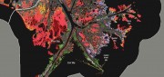
"Wetland" is a generic term covering a wide variety of habitats that are wet for at least some period of time each year,...
March 2, 2016
"Wetland" is a generic term covering a wide variety of habitats that are wet for at least some period of time each year,...
The Vanishing Divide: New solutions bridge the gap between CAD and GIS.
January 19, 2016
For decades, computer-aided design (CAD) and geographic information systems (GIS) have been like oil and water. CAD users,...
January 19, 2016
For decades, computer-aided design (CAD) and geographic information systems (GIS) have been like oil and water. CAD users,...

The Demise of Google Earth Enterprise: VRICON AND ARCGIS EARTH FILL THE GAP
December 28, 2015
Google is ending a 10-year run of Google Earth Enterprise (GEE), which contributed greatly to the market for geospatial “Digital...
December 28, 2015
Google is ending a 10-year run of Google Earth Enterprise (GEE), which contributed greatly to the market for geospatial “Digital...
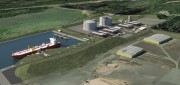
Oregon Preparing for Export: Assessing the Seismic Challenges of a Liquified Natural Gas Plant
December 3, 2015
In the international port of Coos Bay, Ore., construction will begin in late 2016 on a liquefied natural gas (LNG) export...
December 3, 2015
In the international port of Coos Bay, Ore., construction will begin in late 2016 on a liquefied natural gas (LNG) export...

123D Catch for the Masses
November 11, 2015
Stereoscopic imaging, better known as 3D, is not new. In the 16th century, “binocular” images were viewed cross-eyed....
November 11, 2015
Stereoscopic imaging, better known as 3D, is not new. In the 16th century, “binocular” images were viewed cross-eyed....

Blending Realities
November 11, 2015
Imagine designing an object, in 3D and color, using only gaze, gestures, and voice (GGV) commands. Imagine designing an entire...
November 11, 2015
Imagine designing an object, in 3D and color, using only gaze, gestures, and voice (GGV) commands. Imagine designing an entire...