Imaging Notes
Bathymetric LiDAR: Sandy’s Coastal Impact
February 11, 2013
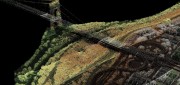
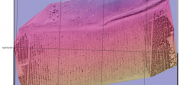
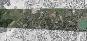
Detailed and accurate charting of the sea bottom along coastlines is vital for environmental monitoring and remediation,...
February 11, 2013
Detailed and accurate charting of the sea bottom along coastlines is vital for environmental monitoring and remediation,...

New GIS Promises to Revolutionize Tax Collection in Kenya
October 24, 2012
IN DEVELOPED COUNTRIES, MOST PEOPLE TAKE FOR GRANTED CERTAIN basic public goods, such as clean drinking water, public education...
October 24, 2012
IN DEVELOPED COUNTRIES, MOST PEOPLE TAKE FOR GRANTED CERTAIN basic public goods, such as clean drinking water, public education...
UAS Industry Poised for Explosion
October 24, 2012
Unmanned aerial systems (UAS, formerly called unmanned aerial vehicles), which the U.S. military has routinely used abroad...
October 24, 2012
Unmanned aerial systems (UAS, formerly called unmanned aerial vehicles), which the U.S. military has routinely used abroad...

Shoshanna Budzianowski: Eye on Earth: Microsoft Continues Investment in Network
August 21, 2012
THE EYE ON EARTH (EOE) NETWORK has garnered a great deal of praise for providing European environmental data openly and transparently,...
August 21, 2012
THE EYE ON EARTH (EOE) NETWORK has garnered a great deal of praise for providing European environmental data openly and transparently,...

Business Uses of Satellite Imagery
June 1, 2012
The public is familiar with satellite imagery through consumer applications — most notably, Google Earth. GeoEye (Herndon,...
June 1, 2012
The public is familiar with satellite imagery through consumer applications — most notably, Google Earth. GeoEye (Herndon,...
Google Earth Builder: Productizing Server Farms for Storing and Processing Geospatial Data
March 24, 2012
Google Earth Builder (GEB), which Google released last fall, enables private companies and government agencies to store and process...
March 24, 2012
Google Earth Builder (GEB), which Google released last fall, enables private companies and government agencies to store and process...
LiDAR Software Update: Companies Respond to Customer Demands
February 25, 2012
The market for software to manage, process, fuse, and visualize LiDAR point cloud data is still very young and amorphous....
February 25, 2012
The market for software to manage, process, fuse, and visualize LiDAR point cloud data is still very young and amorphous....

Radar Update: Applications Abound in Defense, Maritime and Engineering
October 25, 2011
Whether used to view Earth’s surface through clouds or at night, to measure the thickness of polar ice sheets, to map long-abandoned...
October 25, 2011
Whether used to view Earth’s surface through clouds or at night, to measure the thickness of polar ice sheets, to map long-abandoned...
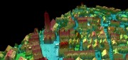
Processing Point Clouds: 3D Data Update
October 25, 2011
Like raster and vector data many years ago, 3D clouds of billions of LiDAR points — which can be colored and very realistic...
October 25, 2011
Like raster and vector data many years ago, 3D clouds of billions of LiDAR points — which can be colored and very realistic...
Google Earth Builder: Advantages for Businesses
June 1, 2011
Google Earth, launched six years ago, expanded by orders of magnitude the market for geospatial technologies. The initial...
June 1, 2011
Google Earth, launched six years ago, expanded by orders of magnitude the market for geospatial technologies. The initial...