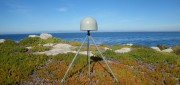
Satellite navigation

Research Roundup: Focus on maritime
October 1, 2020
Of the 273 papers researchers presented this year at the Institute of Navigation’s annual ION GNSS+ conference, which took...
October 1, 2020
Of the 273 papers researchers presented this year at the Institute of Navigation’s annual ION GNSS+ conference, which took...

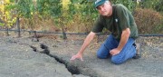
High Precision GPS to Help Automated Bulk Volume Estimation ? Here’s why…
March 5, 2019
The Challenge For the past 150 years, feedlot monitoring has been the responsibility of a select few employees, who visually...
March 5, 2019
The Challenge For the past 150 years, feedlot monitoring has been the responsibility of a select few employees, who visually...

How GNSS Receivers Empower Smart Cities
March 5, 2019
By 2050, more than 60 percent of the world's population is expected to live in urban areas. Cities are facing this rapid...
March 5, 2019
By 2050, more than 60 percent of the world's population is expected to live in urban areas. Cities are facing this rapid...

Managing Canada’s Data
February 7, 2018
From mapping utility poles to mapping radio frequency signal leaks, this company collects and manages much of the country’s...
February 7, 2018
From mapping utility poles to mapping radio frequency signal leaks, this company collects and manages much of the country’s...

The Future of GPS
October 4, 2017
More than half a century after a study by The Aerospace Corporation first laid out the design options for it, the Global...
October 4, 2017
More than half a century after a study by The Aerospace Corporation first laid out the design options for it, the Global...
Geodetic Control over Time and Space in California
August 4, 2017
Interview with Scott Martin, Chief of Geodetic Control and GNSS Surveys, California DoT Matteo Luccio: Scott, what is your...
August 4, 2017
Interview with Scott Martin, Chief of Geodetic Control and GNSS Surveys, California DoT Matteo Luccio: Scott, what is your...
Shifting Ground: USGS on Earth Movement after an Earthquake
June 29, 2017
Ken Hudnut, science advisor for risk reduction, US Geological Survey, talks GPS and earthquakes Editor’s note: In many...
June 29, 2017
Ken Hudnut, science advisor for risk reduction, US Geological Survey, talks GPS and earthquakes Editor’s note: In many...

GNSS Mission: Accomplished
April 12, 2017
Editor’s note: So rarely do new major players arise in the high-precision GNSS industry that we feel the following to be a significant...
April 12, 2017
Editor’s note: So rarely do new major players arise in the high-precision GNSS industry that we feel the following to be a significant...
Championing GNSS for Surveyors
February 21, 2017
Lonnie Sears’ passion for surveying began when he took a surveying class while studying engineering at West Virginia Tech....
February 21, 2017
Lonnie Sears’ passion for surveying began when he took a surveying class while studying engineering at West Virginia Tech....

Moving Dirt Just Right
August 30, 2016
GNSS receivers help steer earth movers, providing users with accurate positions and no complexities. NavCom–a wholly owned...
August 30, 2016
GNSS receivers help steer earth movers, providing users with accurate positions and no complexities. NavCom–a wholly owned...