LiDAR
Shining Light on the Past
October 1, 2020
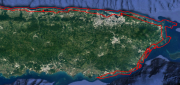
The collection of about 300 giant geoglyphs known as Nasca Lines were etched into the ground in the Peruvian coastal plain...
October 1, 2020
The collection of about 300 giant geoglyphs known as Nasca Lines were etched into the ground in the Peruvian coastal plain...

High Precision GPS to Help Automated Bulk Volume Estimation ? Here’s why…
March 5, 2019
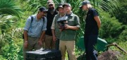
The Challenge For the past 150 years, feedlot monitoring has been the responsibility of a select few employees, who visually...
March 5, 2019
The Challenge For the past 150 years, feedlot monitoring has been the responsibility of a select few employees, who visually...

Standalone UAV Lidar
March 5, 2019
A surveying company developed a self-contained UAV lidar system so teams could gather data without a lidar specialist. Some...
March 5, 2019
A surveying company developed a self-contained UAV lidar system so teams could gather data without a lidar specialist. Some...
After the Storm
November 6, 2018
Post-hurricane coastal mapping is a complex process made easier with airborne bathymetry. Lately, large storms such as hurricanes,...
November 6, 2018
Post-hurricane coastal mapping is a complex process made easier with airborne bathymetry. Lately, large storms such as hurricanes,...

Integrated UAV + Lidar Solutions
February 19, 2018
LiDAR has been around since the early 1960s. In recent years, it has emerged as a key geospatial remote sensing technology:...
February 19, 2018
LiDAR has been around since the early 1960s. In recent years, it has emerged as a key geospatial remote sensing technology:...
FINAL ARTICLE IN THE SERIES on Geospatial Processing & Visualization: Ubisense and Harris Geospatial Solutions
August 4, 2017
The line between vendors of geospatial software and providers of geospatial data is increasingly blurred, as more companies...
August 4, 2017
The line between vendors of geospatial software and providers of geospatial data is increasingly blurred, as more companies...

LIDAR Is Key To Autonomous Vehicles
February 23, 2017
Technology for autonomous vehicles builds on car navigation systems that have been commonplace for years and new collision-avoidance...
February 23, 2017
Technology for autonomous vehicles builds on car navigation systems that have been commonplace for years and new collision-avoidance...

A State Gets Smart: SmarterBetterCities
February 21, 2017
To help formulate a 10-year strategic capital investment plan for the State of Oregon, the state’s Chief Financial Office...
February 21, 2017
To help formulate a 10-year strategic capital investment plan for the State of Oregon, the state’s Chief Financial Office...
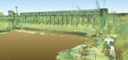
Capturing the Bluestone Dam
February 21, 2017
The Bluestone Damon the New River in West Virginia was completed in 1952. It’s 165 feet high above the stream bed and about...
February 21, 2017
The Bluestone Damon the New River in West Virginia was completed in 1952. It’s 165 feet high above the stream bed and about...

Automating the Mundane
January 19, 2017
You don’t have to work for huge organizations, such as the U.S. Air Force or the U.S. Forest Service, to appreciate the benefits...
January 19, 2017
You don’t have to work for huge organizations, such as the U.S. Air Force or the U.S. Forest Service, to appreciate the benefits...