Photogrammetry

Accuracy with a Phone?
September 27, 2019
Photogrammetry is now possible using consumer devices, and the applications are vast. Continuing improvement in digital...
September 27, 2019
Photogrammetry is now possible using consumer devices, and the applications are vast. Continuing improvement in digital...

NASA’s Eyes on Mars
September 27, 2019
An old imaging technology is outdated for use on Earth, but it’s the perfect fit for today’s remote-sensing needs on Mars. Since...
September 27, 2019
An old imaging technology is outdated for use on Earth, but it’s the perfect fit for today’s remote-sensing needs on Mars. Since...
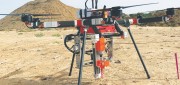
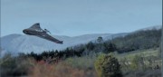
UAV Stakes Out New Ground
September 27, 2019
A flying/staking robot has taken a huge step forward in automation for site layout, including road, rail, utilities, and energy...
September 27, 2019
A flying/staking robot has taken a huge step forward in automation for site layout, including road, rail, utilities, and energy...
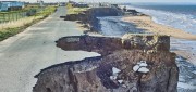
Predicting Crumbling Cliffs
March 5, 2019
Cliff Erosion: a Global Issue In 2012, nine homes in Happisburgh, an historic village on England’s Norfolk coast,...
March 5, 2019
Cliff Erosion: a Global Issue In 2012, nine homes in Happisburgh, an historic village on England’s Norfolk coast,...

Not Everything Requires High Accuracies
November 6, 2018
How feature inspection, assessment, and reporting are now available to non-experts (and experts alike). In the early 2000s,...
November 6, 2018
How feature inspection, assessment, and reporting are now available to non-experts (and experts alike). In the early 2000s,...

Easing the 3D Workflow
February 19, 2018
For 30 years, an Alaska-based company has been producing digital mapping and photogrammetic software to help automate the complex...
February 19, 2018
For 30 years, an Alaska-based company has been producing digital mapping and photogrammetic software to help automate the complex...
Geospatial Analytics-as-a-Service & Platforms
February 7, 2018
The field of Earth Observation (EO) has seen two big changes in recent years: first, the massive increase in the number and variety...
February 7, 2018
The field of Earth Observation (EO) has seen two big changes in recent years: first, the massive increase in the number and variety...
FINAL ARTICLE IN THE SERIES on Geospatial Processing & Visualization: Ubisense and Harris Geospatial Solutions
August 4, 2017
The line between vendors of geospatial software and providers of geospatial data is increasingly blurred, as more companies...
August 4, 2017
The line between vendors of geospatial software and providers of geospatial data is increasingly blurred, as more companies...
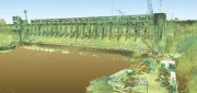
Capturing the Bluestone Dam
February 21, 2017
The Bluestone Damon the New River in West Virginia was completed in 1952. It’s 165 feet high above the stream bed and about...
February 21, 2017
The Bluestone Damon the New River in West Virginia was completed in 1952. It’s 165 feet high above the stream bed and about...
Surveying a Mountain Highway with UAS
February 21, 2017
In the steep canyons of the Republic of Macedonia, AKTOR ADT, an international construction company based in Athens, Greece,...
February 21, 2017
In the steep canyons of the Republic of Macedonia, AKTOR ADT, an international construction company based in Athens, Greece,...