Radar

Research Roundup: Focus on maritime
October 1, 2020
Of the 273 papers researchers presented this year at the Institute of Navigation’s annual ION GNSS+ conference, which took...
October 1, 2020
Of the 273 papers researchers presented this year at the Institute of Navigation’s annual ION GNSS+ conference, which took...
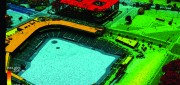
FINAL ARTICLE IN THE SERIES on Geospatial Processing & Visualization: Ubisense and Harris Geospatial Solutions
August 4, 2017
The line between vendors of geospatial software and providers of geospatial data is increasingly blurred, as more companies...
August 4, 2017
The line between vendors of geospatial software and providers of geospatial data is increasingly blurred, as more companies...
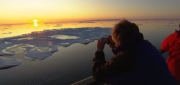
Monitoring Polar Changes: Scientists Deploy Many Tools to Measure Sea Ice Thickness
December 29, 2014
The extent of the polar ice caps is shrinking. This simple fact has been common knowledge since the late 1970s thanks to the added...
December 29, 2014
The extent of the polar ice caps is shrinking. This simple fact has been common knowledge since the late 1970s thanks to the added...
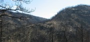
Sensing the Forest for Fuel, Fire, and Recovery
May 6, 2013
Every year, several hundred million hectares of forest, grasslands, and other types of vegetation burn throughout the world,...
May 6, 2013
Every year, several hundred million hectares of forest, grasslands, and other types of vegetation burn throughout the world,...

Radar Update: Applications Abound in Defense, Maritime and Engineering
October 25, 2011
Whether used to view Earth’s surface through clouds or at night, to measure the thickness of polar ice sheets, to map long-abandoned...
October 25, 2011
Whether used to view Earth’s surface through clouds or at night, to measure the thickness of polar ice sheets, to map long-abandoned...
RADAR Gets It Done
June 1, 2010
Has anyone driven over certain desert dunes in Afghanistan during the past few hours? Is a ship on the high seas fishing...
June 1, 2010
Has anyone driven over certain desert dunes in Afghanistan during the past few hours? Is a ship on the high seas fishing...