3D imaging
FINAL ARTICLE IN THE SERIES on Geospatial Processing & Visualization: Ubisense and Harris Geospatial Solutions
August 4, 2017
The line between vendors of geospatial software and providers of geospatial data is increasingly blurred, as more companies...
August 4, 2017
The line between vendors of geospatial software and providers of geospatial data is increasingly blurred, as more companies...

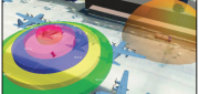
CLIVE: Communicating Risk in 3D
February 21, 2017
Static 3D models of topography and buildings are commonplace in both technical and popular geospatial software. There are still...
February 21, 2017
Static 3D models of topography and buildings are commonplace in both technical and popular geospatial software. There are still...

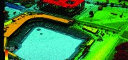
Capturing the Bluestone Dam
February 21, 2017
The Bluestone Damon the New River in West Virginia was completed in 1952. It’s 165 feet high above the stream bed and about...
February 21, 2017
The Bluestone Damon the New River in West Virginia was completed in 1952. It’s 165 feet high above the stream bed and about...
Automating the Mundane
January 19, 2017
You don’t have to work for huge organizations, such as the U.S. Air Force or the U.S. Forest Service, to appreciate the benefits...
January 19, 2017
You don’t have to work for huge organizations, such as the U.S. Air Force or the U.S. Forest Service, to appreciate the benefits...

3D Software, Not Really Like CAD at All
December 1, 2016
Editor’s note: For many firms and practitioners of surveying, photogrammetry, mapping, and remote sensing, traditional...
December 1, 2016
Editor’s note: For many firms and practitioners of surveying, photogrammetry, mapping, and remote sensing, traditional...

Geospatial Solutions: from PIXIA, Luciad, and BAE Systems
October 10, 2016
This series began a year ago by examining alternatives to Google Earth Enterprise, which Google will stop supporting on March...
October 10, 2016
This series began a year ago by examining alternatives to Google Earth Enterprise, which Google will stop supporting on March...

The Process of BIM
May 16, 2016
An analysis of Autodesk’s software suite, BIM 360, reveals how BIM can give project stakeholders unique access and insight...
May 16, 2016
An analysis of Autodesk’s software suite, BIM 360, reveals how BIM can give project stakeholders unique access and insight...

The Demise of Google Earth Enterprise: VRICON AND ARCGIS EARTH FILL THE GAP
December 28, 2015
Google is ending a 10-year run of Google Earth Enterprise (GEE), which contributed greatly to the market for geospatial “Digital...
December 28, 2015
Google is ending a 10-year run of Google Earth Enterprise (GEE), which contributed greatly to the market for geospatial “Digital...

123D Catch for the Masses
November 11, 2015
Stereoscopic imaging, better known as 3D, is not new. In the 16th century, “binocular” images were viewed cross-eyed....
November 11, 2015
Stereoscopic imaging, better known as 3D, is not new. In the 16th century, “binocular” images were viewed cross-eyed....

Blending Realities
November 11, 2015
Imagine designing an object, in 3D and color, using only gaze, gestures, and voice (GGV) commands. Imagine designing an entire...
November 11, 2015
Imagine designing an object, in 3D and color, using only gaze, gestures, and voice (GGV) commands. Imagine designing an entire...