Interviews
Geodetic Control over Time and Space in California
August 4, 2017
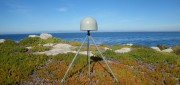
Interview with Scott Martin, Chief of Geodetic Control and GNSS Surveys, California DoT Matteo Luccio: Scott, what is your...
August 4, 2017
Interview with Scott Martin, Chief of Geodetic Control and GNSS Surveys, California DoT Matteo Luccio: Scott, what is your...
Advancing GNSS, Full Interview
May 16, 2016
Interview with Septentrio’s Business Development Manager, Jan Van Hees, and R&D Director, Bruno Bougard Septentrio...
May 16, 2016
Interview with Septentrio’s Business Development Manager, Jan Van Hees, and R&D Director, Bruno Bougard Septentrio...

Going Beyond Global Forest Change Modeling Toward Big Earth-system Sustainability
July 7, 2014
One of the more impressive earth observation achievements in recent years was the collaboration between Google and the University...
July 7, 2014
One of the more impressive earth observation achievements in recent years was the collaboration between Google and the University...
Google Earth Outreach Continues Collaborations for Earth Modeling and Monitoring
June 10, 2014
Google Earth is all about putting things in geographic context, aiding literacy and helping users in discovery. This capacity...
June 10, 2014
Google Earth is all about putting things in geographic context, aiding literacy and helping users in discovery. This capacity...

UNEP Takes Advantage of Today’s Technology for Better and Cheaper Monitoring
May 28, 2014
The United Nations Environment Program is responsible for assisting countries in the collection of environmental data for more...
May 28, 2014
The United Nations Environment Program is responsible for assisting countries in the collection of environmental data for more...

Advocating for Geography Education: Interview with Kirk Goldsberry
December 17, 2013
A recent opinion piece by Kirk Goldsberry, visiting scholar at Harvard University, gained a good deal of attention because...
December 17, 2013
A recent opinion piece by Kirk Goldsberry, visiting scholar at Harvard University, gained a good deal of attention because...

SkyTruth Hopes to Make Skytruthing Into a Verb
October 15, 2013
SkyTruth has a mission to use remote sensing and digital mapping to educate the public and policymakers about the environmental...
October 15, 2013
SkyTruth has a mission to use remote sensing and digital mapping to educate the public and policymakers about the environmental...
Applying Spatial and Temporal Intelligence to Marine Spatial Planning
August 5, 2013
There's an ongoing need to apply spatial and temporal intelligence to make sense of change. The Pacific Marine Analysis and Research...
August 5, 2013
There's an ongoing need to apply spatial and temporal intelligence to make sense of change. The Pacific Marine Analysis and Research...

Spreading the Inspiration of Earth Observation
April 8, 2013
Research scientists continue to add to our understanding of Earth systems, thanks to the global Earth observation capacity....
April 8, 2013
Research scientists continue to add to our understanding of Earth systems, thanks to the global Earth observation capacity....
exactEarth Provides Unique Insight Into Global Ocean Traffic
March 11, 2013
exactEarth has successfully launched an earth observation satellite constellation to track Automated Identification System...
March 11, 2013
exactEarth has successfully launched an earth observation satellite constellation to track Automated Identification System...