Precision agriculture
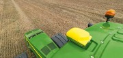
Precision agriculture grows with RTK
October 1, 2020
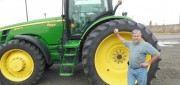
Precision agriculture — the practice of optimizing inputs of seed, water, and fertilizers while maximizing yields by mapping...
October 1, 2020
Precision agriculture — the practice of optimizing inputs of seed, water, and fertilizers while maximizing yields by mapping...
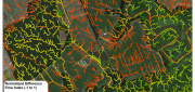
LiDAR, GIS and the Chesapeake Conservancy: Precision Conservation
June 2, 2016
Building on the practice of precision agriculture and exploiting recent computer advances, the Chesapeake Conservancy (CC)...
June 2, 2016
Building on the practice of precision agriculture and exploiting recent computer advances, the Chesapeake Conservancy (CC)...
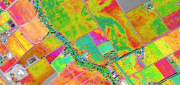
Satellite Imagery for Precision Agriculture
March 13, 2016
Precision agriculture consists primarily of using geospatial technologies to map spatial variations in crop and soil conditions...
March 13, 2016
Precision agriculture consists primarily of using geospatial technologies to map spatial variations in crop and soil conditions...

Satellite Signals Steer Farmers Straight
December 29, 2014
Precision agriculture combines GPS, remote sensing, and GIS to capture large amounts of georeferenced data on spatial variations...
December 29, 2014
Precision agriculture combines GPS, remote sensing, and GIS to capture large amounts of georeferenced data on spatial variations...
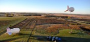
Tethered Aerostats Provide Another Option in the Sky
October 31, 2014
Geospatial professionals are able to choose from an increasingly wide array of platforms on which to deploy ever more accurate...
October 31, 2014
Geospatial professionals are able to choose from an increasingly wide array of platforms on which to deploy ever more accurate...
State of: Precision Agriculture
July 8, 2014
One of the fastest growing areas of application for geospatial technologies, precision agriculture is a way to optimize agricultural...
July 8, 2014
One of the fastest growing areas of application for geospatial technologies, precision agriculture is a way to optimize agricultural...

UAS for Agriculture, Ready for Take-off
February 26, 2014
Unmanned aerial systems (UAS) have recently become ubiquitous in the mass media and in trade publications, due to a variety...
February 26, 2014
Unmanned aerial systems (UAS) have recently become ubiquitous in the mass media and in trade publications, due to a variety...

Precision Agriculture: Sensors Drive Agricultural Efficiency
January 22, 2013
If Old McDonald had a farm today, he could manage it from his laptop computer and map it with an application on his handheld...
January 22, 2013
If Old McDonald had a farm today, he could manage it from his laptop computer and map it with an application on his handheld...

Mike Martinez: Trimble Continues to Innovate to Meet Growing Agriculture Demands
January 7, 2013
The application of GNSS sensors and machine control to agriculture, with a prescriptive approach that matches maps of the field...
January 7, 2013
The application of GNSS sensors and machine control to agriculture, with a prescriptive approach that matches maps of the field...