• Home
  • About
    • About PBD
    • What Are Geospatial Technologies?
    • Matteo Luccio’s Bio
    • Conferences
    • Our Name
  • Topics
    • 3D imaging
    • Aerial photography
    • Bathymetry
    • Building Information Modeling (BIM)
    • CAD
    • Energy
    • Cadaster
    • Environment
    • Geodesy
    • GIS
    • LiDAR
    • Mapping
    • Navigation
    • Open source software
    • Other
    • Photogrammetry
    • Precision agriculture
    • Radar
    • Remote sensing
    • Satellite imaging
    • Satellite navigation
    • Seismology
    • Sensors
    • Surveying
    • UAS
    • Tracking
  • Magazines
    • Apogeo Spatial
    • ArcNews
    • ArcWatch
    • CE News
    • Earth Imaging Journal
    • GEOInformatics
    • GeoWorld
    • GIM International
    • Heights
    • Informed Infrastruct.
    • Imaging Notes
    • Point of Beginning
    • Prof. Surveyor Mag.
    • Sensors & Systems
    • Septentrio Insights
    • The American Surveyor
    • xyHt
  • Formats
    • Feature articles
    • Short articles
    • Interviews
    • News items
    • Other
  • All
  • Clients
  • Tips
    • Gripes
    • Tips
  • Contact Us
 

CLIVE: Communicating Risk in 3D

Posted by: Matteo    Tags:      Posted date:  February 21, 2017  |  No comment


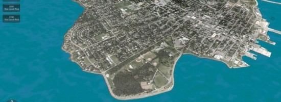
Static 3D models of topography and buildings are commonplace in both technical and popular geospatial software. There are still very few 3D tools, however, that enable users to geo-visualize dynamic phenomena, such as the effects of climate change.

One such tool called CLIVE, for Coastal Impact Visualization Environment, displays change due to oceanic thermal expansion and consequent coastal erosion. It was co-developed by Nick Hedley, a professor at Simon Fraser University and the director of its Spatial Interface Research Laboratory, and Adam Fenech, a professor at the University of Prince Edward Island (UPEI) and the director of its Climate Research Laboratory.

By combining their expertise, Hedley and Fenech and two of their students created this tool to be accurate yet also easy to use by people with little or no geospatial training. “There’s a real balance of expertise,” says Hedley. “We bring the geovisual, analytical interface intelligence, and he brings the long-term climate science expertise to the table.”

Read more...


Want to say something?


  Cancel Reply


4 + = thirteen

« Capturing the Bluestone Dam
A Global Geodetic Roadmap »


Copyright (c) 2012 by Pale Blue Dot, LLC / For information write to matteo@palebluedotllc.com