• Home
  • About
    • About PBD
    • What Are Geospatial Technologies?
    • Matteo Luccio’s Bio
    • Conferences
    • Our Name
  • Topics
    • 3D imaging
    • Aerial photography
    • Bathymetry
    • Building Information Modeling (BIM)
    • CAD
    • Energy
    • Cadaster
    • Environment
    • Geodesy
    • GIS
    • LiDAR
    • Mapping
    • Navigation
    • Open source software
    • Other
    • Photogrammetry
    • Precision agriculture
    • Radar
    • Remote sensing
    • Satellite imaging
    • Satellite navigation
    • Seismology
    • Sensors
    • Surveying
    • UAS
    • Tracking
  • Magazines
    • Apogeo Spatial
    • ArcNews
    • ArcWatch
    • CE News
    • Earth Imaging Journal
    • GEOInformatics
    • GeoWorld
    • GIM International
    • Heights
    • Informed Infrastruct.
    • Imaging Notes
    • Point of Beginning
    • Prof. Surveyor Mag.
    • Sensors & Systems
    • Septentrio Insights
    • The American Surveyor
    • xyHt
  • Formats
    • Feature articles
    • Short articles
    • Interviews
    • News items
    • Other
  • All
  • Clients
  • Tips
    • Gripes
    • Tips
  • Contact Us
 

A State Gets Smart: SmarterBetterCities

Posted by: Matteo    Tags:      Posted date:  February 21, 2017  |  No comment


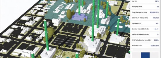
To help formulate a 10-year strategic capital investment plan for the State of Oregon, the state’s Chief Financial Office (CFO) wanted to develop a dynamic, immersive, and collaborative visual platform that would illuminate key issues often lost in a tabular summary. Its audience was the public and the state’s legislature, and its goal was to visualize the plan in the form of a dynamic 3D web-mapping platform accessible from consumer devices.

In a radical departure from government style, CFO decided to pursue cheap, easy, and perhaps open-source technology, even if unproven. When a group of agency leadership saw the initial version—a 3D visual of a 100-year flood plain consuming state-owned office buildings—and immediately began to collaboratively discuss the issues it raised, CFO staff knew that they had met their goal.

While CFO started with a pilot area of the state capital, its intent is to visualize the state’s entire portfolio, as well as such external factors as natural hazards. However, web-based 3D runtime technology is still an evolving technology. To solve some of challenges it poses, CFO partnered with SmarterBetter-Cities, using their CloudCities platform (which was in beta at the time but has since been launched). This enabled CFO to accomplish tasks not yet possible with their underlying GIS technology.

Read more…


Want to say something?


  Cancel Reply


+ 6 = twelve

« Geospatial PPPs
Championing GNSS for Surveyors »


Copyright (c) 2012 by Pale Blue Dot, LLC / For information write to matteo@palebluedotllc.com