• Home
  • About
    • About PBD
    • What Are Geospatial Technologies?
    • Matteo Luccio’s Bio
    • Conferences
    • Our Name
  • Topics
    • 3D imaging
    • Aerial photography
    • Bathymetry
    • Building Information Modeling (BIM)
    • CAD
    • Energy
    • Cadaster
    • Environment
    • Geodesy
    • GIS
    • LiDAR
    • Mapping
    • Navigation
    • Open source software
    • Other
    • Photogrammetry
    • Precision agriculture
    • Radar
    • Remote sensing
    • Satellite imaging
    • Satellite navigation
    • Seismology
    • Sensors
    • Surveying
    • UAS
    • Tracking
  • Magazines
    • Apogeo Spatial
    • ArcNews
    • ArcWatch
    • CE News
    • Earth Imaging Journal
    • GEOInformatics
    • GeoWorld
    • GIM International
    • Heights
    • Informed Infrastruct.
    • Imaging Notes
    • Point of Beginning
    • Prof. Surveyor Mag.
    • Sensors & Systems
    • Septentrio Insights
    • The American Surveyor
    • xyHt
  • Formats
    • Feature articles
    • Short articles
    • Interviews
    • News items
    • Other
  • All
  • Clients
  • Tips
    • Gripes
    • Tips
  • Contact Us
 

Standalone UAV Lidar

Posted by: Matteo    Tags:      Posted date:  March 5, 2019  |  No comment


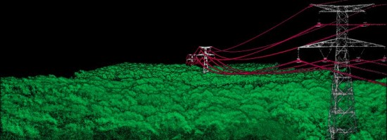
A surveying company developed a self-contained UAV lidar system so teams could gather data without a lidar specialist.

Some companies are born (and some are transformed) when their founders switch their focus from using a tool for projects to developing that tool and selling it.

An example is the GIS giant Esri, which, for its first dozen years of existence, used the then-nascent technology of computational geography to perform analyses while advancing the tools with each project. In 1981 Esri switched to building GIS as a product for other people to use.

Likewise, the surveyors and geomatics specialists at the French aerial mapping services company L’Avion Jaune (“The Yellow Airplane”) spent 13 years pioneering UAV surveying, then they realized that there was a market for UAV-based lidar solutions.

When the leaders at L’Avion Jaune needed a lightweight and compact UAV lidar, they started an internal R&D project and developed the Mapper I. Then in 2015, they spun that project out by founding YellowScan SAS. (In turn, the U.S. company YellowScan, Inc. is a fully-owned subsidiary of YellowScan SAS.)

The company “has been evolving rapidly and growing very fast,” says Thibaud Capra, an application engineer at YellowScan, Inc. “L’Avion Jaune started with three people, and today YellowScan has more than 30 staff.”

Read more…


Want to say something?


  Cancel Reply


1 × four =

« Street Views of the Water
Predicting Crumbling Cliffs »


Copyright (c) 2012 by Pale Blue Dot, LLC / For information write to matteo@palebluedotllc.com