Street Views of the Water
Mapping rivers above and below the surface creates great opportunity for engineers and stewards.
The way maps are produced and displayed varies greatly, depending on their extent, their intended use, and the peculiar challenges of each environment.
Mapping a small river is hard to do from the air because vegetation often obstructs the line of sight; helicopter time is very expensive; and small UAVs quickly run out of battery power, cannot carry bathymetric lidar, and, if flown low enough to see beneath tree branches, are constantly at risk of running into them. Therefore, the task is best accomplished from a boat or even by wading in the water.
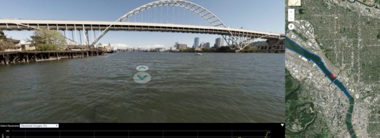
Additionally, water-resource managers often need much more data than just the contours of a river’s banks and the bathymetry of its bottom. They also need data about such things as water quality (turbidity, pH, electrical conductivity, salinity, dissolved oxygen content, ammonia, etc.), temperature and thermocline, and surface debris.
Because large portions of many rivers are in remote areas and hidden from view by vegetation and topography, virtual 3D tours can help engineers develop river preservation and restoration projects and the rivers’ stewards—whether government agencies or private nonprofits—generate public support for these projects.
FishViews, a start-up based in Wimberley, Texas, has developed a kit to map rivers and software to display the georeferenced imagery in 3D with underwater images and associated water-quality data. The company sells or leases this equipment or collects the data directly, then processes the data, produces virtual river tours, and posts them on its website. The San Diego River Park Foundation (SDRPF) bought one of these kits and is using it to map the San Diego River.