Feature articles

Completing the Lake Wobegon Trail: Vision to Design
April 9, 2015
The urban areas in Stearns County, Minnesota, are like islands in a sea of corn, soybean and dairy farms. Through this bucolic...
April 9, 2015
The urban areas in Stearns County, Minnesota, are like islands in a sea of corn, soybean and dairy farms. Through this bucolic...

Real-Time Monitoring A Hit Down Under
January 11, 2015
In the heart of Brisbane, Australia’s third most populous city, constructioncompany Watpac Australia Pty. Ltd. has a contract...
January 11, 2015
In the heart of Brisbane, Australia’s third most populous city, constructioncompany Watpac Australia Pty. Ltd. has a contract...
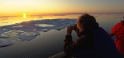
Monitoring Polar Changes: Scientists Deploy Many Tools to Measure Sea Ice Thickness
December 29, 2014
The extent of the polar ice caps is shrinking. This simple fact has been common knowledge since the late 1970s thanks to the added...
December 29, 2014
The extent of the polar ice caps is shrinking. This simple fact has been common knowledge since the late 1970s thanks to the added...
Imagery Options for Esri Users. Esri’s ArcGIS Marketplace
December 29, 2014
IS users increasingly expect content to come with their platform, rather than be an add-on. To help meet this expectation,...
December 29, 2014
IS users increasingly expect content to come with their platform, rather than be an add-on. To help meet this expectation,...
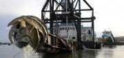
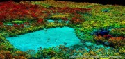
Survey. Dredge. Repeat. Keeping the Columbia River Navigable
December 29, 2014
As the skipper of Galileo 3, a 30-foot sailboat on the Columbia River, I tell my crew that I am comfortable with 15 feet...
December 29, 2014
As the skipper of Galileo 3, a 30-foot sailboat on the Columbia River, I tell my crew that I am comfortable with 15 feet...
From Shore to Floor
October 16, 2014
More than 90% of the world’s trade is carried by sea, according to the International Maritime Organization. Therefore,...
October 16, 2014
More than 90% of the world’s trade is carried by sea, according to the International Maritime Organization. Therefore,...
Mapping People: Human Landscape
August 12, 2014
The executive director of an international nonprofit organization needs to map all the hospitals, clinics, and first aid facilities...
August 12, 2014
The executive director of an international nonprofit organization needs to map all the hospitals, clinics, and first aid facilities...

Extraterrestrial Photogrammetry
July 8, 2014
On Earth, photogrammetrists can normally use manmade objects in their frame—such as a road of known width or a curb of known...
July 8, 2014
On Earth, photogrammetrists can normally use manmade objects in their frame—such as a road of known width or a curb of known...
Improving Global Carbon Estimates with LiDAR
May 13, 2014
International efforts to mitigate climate change hinge on limiting global anthropogenic CO2 emissions. About 12 percent of these...
May 13, 2014
International efforts to mitigate climate change hinge on limiting global anthropogenic CO2 emissions. About 12 percent of these...
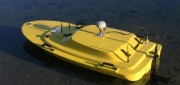
Hydrography by Remote
May 6, 2014
Before they even start taking measurements, surveyors often have to deal with such practical challenges as how to access...
May 6, 2014
Before they even start taking measurements, surveyors often have to deal with such practical challenges as how to access...