All

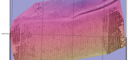
Mark Romano: Earth Eye Makes Inroads in Sensor Fusion
November 5, 2012
Earth Eye is a relatively new company that has been focused on LiDAR data capture, and the fusion of LiDAR with other sensor...
November 5, 2012
Earth Eye is a relatively new company that has been focused on LiDAR data capture, and the fusion of LiDAR with other sensor...
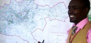
New GIS Promises to Revolutionize Tax Collection in Kenya
October 24, 2012
IN DEVELOPED COUNTRIES, MOST PEOPLE TAKE FOR GRANTED CERTAIN basic public goods, such as clean drinking water, public education...
October 24, 2012
IN DEVELOPED COUNTRIES, MOST PEOPLE TAKE FOR GRANTED CERTAIN basic public goods, such as clean drinking water, public education...
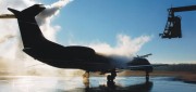
UAS Industry Poised for Explosion
October 24, 2012
Unmanned aerial systems (UAS, formerly called unmanned aerial vehicles), which the U.S. military has routinely used abroad...
October 24, 2012
Unmanned aerial systems (UAS, formerly called unmanned aerial vehicles), which the U.S. military has routinely used abroad...

Sewer Heat Recovery Provides Low-Cost Recycled Energy
October 24, 2012
In every urban area, heat that humans have generated to shower, wash clothes, cook, and so on flows underground — in the sewers,...
October 24, 2012
In every urban area, heat that humans have generated to shower, wash clothes, cook, and so on flows underground — in the sewers,...

Shoshanna Budzianowski: Eye on Earth: Microsoft Continues Investment in Network
August 21, 2012
THE EYE ON EARTH (EOE) NETWORK has garnered a great deal of praise for providing European environmental data openly and transparently,...
August 21, 2012
THE EYE ON EARTH (EOE) NETWORK has garnered a great deal of praise for providing European environmental data openly and transparently,...
Biosensors for Environmental Monitoring
July 31, 2012
The idea for biosensors — using some part of an organism to generate a signal to measure or monitor the presence of a substance...
July 31, 2012
The idea for biosensors — using some part of an organism to generate a signal to measure or monitor the presence of a substance...
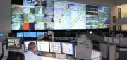
Traffic Data Hits on Real-Time Needs
June 25, 2012
For decades, state and local departments of transportation have collected traffic data by means of a variety of methods — including...
June 25, 2012
For decades, state and local departments of transportation have collected traffic data by means of a variety of methods — including...

Wade Larson and George Tyc: UrtheCast Promises a Live Video Feed of Earth from Space
June 12, 2012
UrtheCast is a company created to provide the first live high-definition video feed of Earth from space. Working jointly...
June 12, 2012
UrtheCast is a company created to provide the first live high-definition video feed of Earth from space. Working jointly...

Business Uses of Satellite Imagery
June 1, 2012
The public is familiar with satellite imagery through consumer applications — most notably, Google Earth. GeoEye (Herndon,...
June 1, 2012
The public is familiar with satellite imagery through consumer applications — most notably, Google Earth. GeoEye (Herndon,...

Stephen R.J. Sheppard: Collaborative Visualization to Advance Landscape Planning
April 15, 2012
Recently the University of British Columbia unveiled The Decision Theatre, an interactive and immersive computer visualization...
April 15, 2012
Recently the University of British Columbia unveiled The Decision Theatre, an interactive and immersive computer visualization...