Environment
Maximizing the Sun: Solar energy grows in part due to aerial imaging and surveying
April 10, 2015
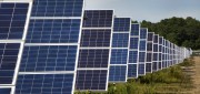
Solar power is booming in the United States. “Every three weeks,” President Obama said in his 2015 State of the Union...
April 10, 2015
Solar power is booming in the United States. “Every three weeks,” President Obama said in his 2015 State of the Union...
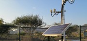
Mobile System Alerts Dubai Drivers of Approaching Sandstorms
October 16, 2014
Periodically, large sandstorms and low-visibility conditions wreak havoc in the Middle East, with potentially deadly consequences...
October 16, 2014
Periodically, large sandstorms and low-visibility conditions wreak havoc in the Middle East, with potentially deadly consequences...

Going Beyond Global Forest Change Modeling Toward Big Earth-system Sustainability
July 7, 2014
One of the more impressive earth observation achievements in recent years was the collaboration between Google and the University...
July 7, 2014
One of the more impressive earth observation achievements in recent years was the collaboration between Google and the University...

Google Earth Outreach Continues Collaborations for Earth Modeling and Monitoring
June 10, 2014
Google Earth is all about putting things in geographic context, aiding literacy and helping users in discovery. This capacity...
June 10, 2014
Google Earth is all about putting things in geographic context, aiding literacy and helping users in discovery. This capacity...

UNEP Takes Advantage of Today’s Technology for Better and Cheaper Monitoring
May 28, 2014
The United Nations Environment Program is responsible for assisting countries in the collection of environmental data for more...
May 28, 2014
The United Nations Environment Program is responsible for assisting countries in the collection of environmental data for more...
Improving Global Carbon Estimates with LiDAR
May 13, 2014
International efforts to mitigate climate change hinge on limiting global anthropogenic CO2 emissions. About 12 percent of these...
May 13, 2014
International efforts to mitigate climate change hinge on limiting global anthropogenic CO2 emissions. About 12 percent of these...
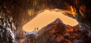
Under Thin Ice: Mapping changing glaciers from the inside
February 27, 2014
Mountaineers climb mountains. Cavers explore caves. Surveyors measure and map. In Oregon, a small team of people with all three...
February 27, 2014
Mountaineers climb mountains. Cavers explore caves. Surveyors measure and map. In Oregon, a small team of people with all three...

SkyTruth Hopes to Make Skytruthing Into a Verb
October 15, 2013
SkyTruth has a mission to use remote sensing and digital mapping to educate the public and policymakers about the environmental...
October 15, 2013
SkyTruth has a mission to use remote sensing and digital mapping to educate the public and policymakers about the environmental...
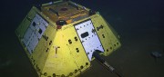
The Abyss, Now Live on Your Desktop
August 5, 2013
The advent of Earth-observation satellites transformed how we view our planet—from occasional snapshots to near continuous,...
August 5, 2013
The advent of Earth-observation satellites transformed how we view our planet—from occasional snapshots to near continuous,...
Applying Spatial and Temporal Intelligence to Marine Spatial Planning
August 5, 2013
There's an ongoing need to apply spatial and temporal intelligence to make sense of change. The Pacific Marine Analysis and Research...
August 5, 2013
There's an ongoing need to apply spatial and temporal intelligence to make sense of change. The Pacific Marine Analysis and Research...