xyHt

Advancing GNSS, Full Interview
May 16, 2016
Interview with Septentrio’s Business Development Manager, Jan Van Hees, and R&D Director, Bruno Bougard Septentrio...
May 16, 2016
Interview with Septentrio’s Business Development Manager, Jan Van Hees, and R&D Director, Bruno Bougard Septentrio...
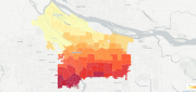
Using CartoDB: From creating a map in eight minutes to creating market predictions
May 16, 2016
Among the many mapping programs available, CartoDB stands out for its ease of use and sophistication. It allows users to import...
May 16, 2016
Among the many mapping programs available, CartoDB stands out for its ease of use and sophistication. It allows users to import...
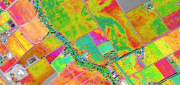
Satellite Imagery for Precision Agriculture
March 13, 2016
Precision agriculture consists primarily of using geospatial technologies to map spatial variations in crop and soil conditions...
March 13, 2016
Precision agriculture consists primarily of using geospatial technologies to map spatial variations in crop and soil conditions...

ADVANCING GNSS: A profile of Septentrio
March 7, 2016
Septentrio makes high-precision GNSS receivers for commercial and scientific applications. Its origins are in European space...
March 7, 2016
Septentrio makes high-precision GNSS receivers for commercial and scientific applications. Its origins are in European space...

123D Catch for the Masses
November 11, 2015
Stereoscopic imaging, better known as 3D, is not new. In the 16th century, “binocular” images were viewed cross-eyed....
November 11, 2015
Stereoscopic imaging, better known as 3D, is not new. In the 16th century, “binocular” images were viewed cross-eyed....

Blending Realities
November 11, 2015
Imagine designing an object, in 3D and color, using only gaze, gestures, and voice (GGV) commands. Imagine designing an entire...
November 11, 2015
Imagine designing an object, in 3D and color, using only gaze, gestures, and voice (GGV) commands. Imagine designing an entire...

Mapping the Appalachian Trail (Part 1 of 2)
May 26, 2015
How the AT was created and surveyed, from Avery’s wheel to GPS The Appalachian Trail (AT) is very old, very long, and iconic....
May 26, 2015
How the AT was created and surveyed, from Avery’s wheel to GPS The Appalachian Trail (AT) is very old, very long, and iconic....

Navigating Without Addresses
April 10, 2015
New codes aim to bring billions of people into the geospatial market When we mail a letter to an address in an industrialized...
April 10, 2015
New codes aim to bring billions of people into the geospatial market When we mail a letter to an address in an industrialized...

Tracking Aircraft in Flight
April 10, 2015
The disappearance of Malaysia Airlines Flight 370 on March 8, 2014, with 239 people on board, was both tragic and stunning....
April 10, 2015
The disappearance of Malaysia Airlines Flight 370 on March 8, 2014, with 239 people on board, was both tragic and stunning....

Maximizing the Sun: Solar energy grows in part due to aerial imaging and surveying
April 10, 2015
Solar power is booming in the United States. “Every three weeks,” President Obama said in his 2015 State of the Union...
April 10, 2015
Solar power is booming in the United States. “Every three weeks,” President Obama said in his 2015 State of the Union...