Publications

Geospatial Solutions: from PIXIA, Luciad, and BAE Systems
October 10, 2016
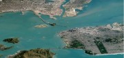
This series began a year ago by examining alternatives to Google Earth Enterprise, which Google will stop supporting on March...
October 10, 2016
This series began a year ago by examining alternatives to Google Earth Enterprise, which Google will stop supporting on March...
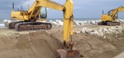
Moving Dirt Just Right
August 30, 2016
GNSS receivers help steer earth movers, providing users with accurate positions and no complexities. NavCom–a wholly owned...
August 30, 2016
GNSS receivers help steer earth movers, providing users with accurate positions and no complexities. NavCom–a wholly owned...

Space Engineer In Training
June 2, 2016
Last summer, NASA dropped three small airplanes from 100 feet in tests meant to simulate severe but survivable crashes. It collected...
June 2, 2016
Last summer, NASA dropped three small airplanes from 100 feet in tests meant to simulate severe but survivable crashes. It collected...
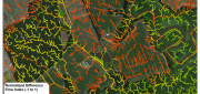
LiDAR, GIS and the Chesapeake Conservancy: Precision Conservation
June 2, 2016
Building on the practice of precision agriculture and exploiting recent computer advances, the Chesapeake Conservancy (CC)...
June 2, 2016
Building on the practice of precision agriculture and exploiting recent computer advances, the Chesapeake Conservancy (CC)...

The Process of BIM
May 16, 2016
An analysis of Autodesk’s software suite, BIM 360, reveals how BIM can give project stakeholders unique access and insight...
May 16, 2016
An analysis of Autodesk’s software suite, BIM 360, reveals how BIM can give project stakeholders unique access and insight...
Advancing GNSS, Full Interview
May 16, 2016
Interview with Septentrio’s Business Development Manager, Jan Van Hees, and R&D Director, Bruno Bougard Septentrio...
May 16, 2016
Interview with Septentrio’s Business Development Manager, Jan Van Hees, and R&D Director, Bruno Bougard Septentrio...
Using CartoDB: From creating a map in eight minutes to creating market predictions
May 16, 2016
Among the many mapping programs available, CartoDB stands out for its ease of use and sophistication. It allows users to import...
May 16, 2016
Among the many mapping programs available, CartoDB stands out for its ease of use and sophistication. It allows users to import...

Planet Labs: Democratizing the Data of Earth, Daily
May 16, 2016
THE ADVENT OF MASS-PRODUCED, MINIATURE satellites is radically changing Earth observation by vastly increasing the imagery’s...
May 16, 2016
THE ADVENT OF MASS-PRODUCED, MINIATURE satellites is radically changing Earth observation by vastly increasing the imagery’s...
Companies Pick Up Where Google Earth Enterprise Leaves off
May 16, 2016
The waves created by Google’s announcement that it will stop supporting Google Earth Enterprise (GEE) in the spring of 2017...
May 16, 2016
The waves created by Google’s announcement that it will stop supporting Google Earth Enterprise (GEE) in the spring of 2017...

Data Management & Visualization: Married Or Separated?
March 21, 2016
Large users of geospatial data are searching for alternatives to Google Earth Enterprise (GEE), which Google will discontinue...
March 21, 2016
Large users of geospatial data are searching for alternatives to Google Earth Enterprise (GEE), which Google will discontinue...