Mapping and cartography
LiDAR, GIS and the Chesapeake Conservancy: Precision Conservation
June 2, 2016
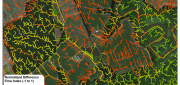
Building on the practice of precision agriculture and exploiting recent computer advances, the Chesapeake Conservancy (CC)...
June 2, 2016
Building on the practice of precision agriculture and exploiting recent computer advances, the Chesapeake Conservancy (CC)...
Using CartoDB: From creating a map in eight minutes to creating market predictions
May 16, 2016
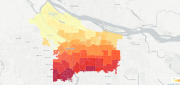
Among the many mapping programs available, CartoDB stands out for its ease of use and sophistication. It allows users to import...
May 16, 2016
Among the many mapping programs available, CartoDB stands out for its ease of use and sophistication. It allows users to import...

Planet Labs: Democratizing the Data of Earth, Daily
May 16, 2016
THE ADVENT OF MASS-PRODUCED, MINIATURE satellites is radically changing Earth observation by vastly increasing the imagery’s...
May 16, 2016
THE ADVENT OF MASS-PRODUCED, MINIATURE satellites is radically changing Earth observation by vastly increasing the imagery’s...

Data Management & Visualization: Married Or Separated?
March 21, 2016
Large users of geospatial data are searching for alternatives to Google Earth Enterprise (GEE), which Google will discontinue...
March 21, 2016
Large users of geospatial data are searching for alternatives to Google Earth Enterprise (GEE), which Google will discontinue...
Wetlands Worth their Weight
March 2, 2016
"Wetland" is a generic term covering a wide variety of habitats that are wet for at least some period of time each year,...
March 2, 2016
"Wetland" is a generic term covering a wide variety of habitats that are wet for at least some period of time each year,...

The Demise of Google Earth Enterprise: VRICON AND ARCGIS EARTH FILL THE GAP
December 28, 2015
Google is ending a 10-year run of Google Earth Enterprise (GEE), which contributed greatly to the market for geospatial “Digital...
December 28, 2015
Google is ending a 10-year run of Google Earth Enterprise (GEE), which contributed greatly to the market for geospatial “Digital...

Trimble UAS Answers Tall Task
November 9, 2015
In the steep canyons of the Republic of Macedonia — a landlocked Balkan nation of mountains, lakes and ancient towns — international...
November 9, 2015
In the steep canyons of the Republic of Macedonia — a landlocked Balkan nation of mountains, lakes and ancient towns — international...
See the Light: LiDAR Data Help Expose Landslide Hazards
October 12, 2015
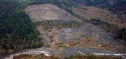
On March 22, 2014, four miles east of Oso, Wash., a portion of an unstable hill collapsed, sending mud and debris across...
October 12, 2015
On March 22, 2014, four miles east of Oso, Wash., a portion of an unstable hill collapsed, sending mud and debris across...

Moving Forward with UAS Mapping
June 16, 2015
For geospatial professionals, the most exciting aspect of the current explosion in unmanned aircraft systems (UASs) is using...
June 16, 2015
For geospatial professionals, the most exciting aspect of the current explosion in unmanned aircraft systems (UASs) is using...

Mapping the Appalachian Trail (Part 1 of 2)
May 26, 2015
How the AT was created and surveyed, from Avery’s wheel to GPS The Appalachian Trail (AT) is very old, very long, and iconic....
May 26, 2015
How the AT was created and surveyed, from Avery’s wheel to GPS The Appalachian Trail (AT) is very old, very long, and iconic....