• Home
  • About
    • About PBD
    • What Are Geospatial Technologies?
    • Matteo Luccio’s Bio
    • Conferences
    • Our Name
  • Topics
    • 3D imaging
    • Aerial photography
    • Bathymetry
    • Building Information Modeling (BIM)
    • CAD
    • Energy
    • Cadaster
    • Environment
    • Geodesy
    • GIS
    • LiDAR
    • Mapping
    • Navigation
    • Open source software
    • Other
    • Photogrammetry
    • Precision agriculture
    • Radar
    • Remote sensing
    • Satellite imaging
    • Satellite navigation
    • Seismology
    • Sensors
    • Surveying
    • UAS
    • Tracking
  • Magazines
    • Apogeo Spatial
    • ArcNews
    • ArcWatch
    • CE News
    • Earth Imaging Journal
    • GEOInformatics
    • GeoWorld
    • GIM International
    • Heights
    • Informed Infrastruct.
    • Imaging Notes
    • Point of Beginning
    • Prof. Surveyor Mag.
    • Sensors & Systems
    • Septentrio Insights
    • The American Surveyor
    • xyHt
  • Formats
    • Feature articles
    • Short articles
    • Interviews
    • News items
    • Other
  • All
  • Clients
  • Tips
    • Gripes
    • Tips
  • Contact Us
 

See the Light: LiDAR Data Help Expose Landslide Hazards

Posted by: Matteo    Tags:      Posted date:  October 12, 2015  |  No comment


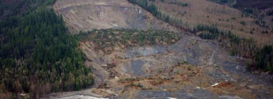
On March 22, 2014, four miles east of Oso, Wash., a portion of an unstable hill collapsed, sending mud and debris across the North Fork of the Stillaguamish River, covering an area of approximately one square mile and devastating a rural neighborhood, killing 43 people. It also dammed the river, causing extensive flooding upstream and blocking State Route 530. Excluding landslides caused by volcanic eruptions, earthquakes or dam collapses, the Oso slide was the deadliest single landslide event in U.S. history.

LiDAR data—if collected, analyzed and disseminated to local residents and policy makers—can be invaluable in mapping landslide hazards. In turn, such mapping can greatly help mitigate the consequences of landslides. After the Oso disaster, interest in landslide hazards grew significantly in Washington as well as Oregon, California and other mountainous states.

Read more…


Want to say something?


  Cancel Reply


five + = 9

« The Urgency of Building Bridges Between EO & Satcom
Trimble UAS Answers Tall Task »


Copyright (c) 2012 by Pale Blue Dot, LLC / For information write to matteo@palebluedotllc.com