Mapping and cartography
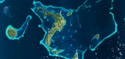
Navigating Without Addresses
April 10, 2015
New codes aim to bring billions of people into the geospatial market When we mail a letter to an address in an industrialized...
April 10, 2015
New codes aim to bring billions of people into the geospatial market When we mail a letter to an address in an industrialized...

Maximizing the Sun: Solar energy grows in part due to aerial imaging and surveying
April 10, 2015
Solar power is booming in the United States. “Every three weeks,” President Obama said in his 2015 State of the Union...
April 10, 2015
Solar power is booming in the United States. “Every three weeks,” President Obama said in his 2015 State of the Union...

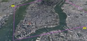
Developing the Map of the Future
April 9, 2015
Geospatial technology is changing. Now geographic information system (GIS) software is ingesting, organizing and visualizing...
April 9, 2015
Geospatial technology is changing. Now geographic information system (GIS) software is ingesting, organizing and visualizing...

Completing the Lake Wobegon Trail: Vision to Design
April 9, 2015
The urban areas in Stearns County, Minnesota, are like islands in a sea of corn, soybean and dairy farms. Through this bucolic...
April 9, 2015
The urban areas in Stearns County, Minnesota, are like islands in a sea of corn, soybean and dairy farms. Through this bucolic...

Real-Time Monitoring A Hit Down Under
January 11, 2015
In the heart of Brisbane, Australia’s third most populous city, constructioncompany Watpac Australia Pty. Ltd. has a contract...
January 11, 2015
In the heart of Brisbane, Australia’s third most populous city, constructioncompany Watpac Australia Pty. Ltd. has a contract...
Imagery Options for Esri Users. Esri’s ArcGIS Marketplace
December 29, 2014
IS users increasingly expect content to come with their platform, rather than be an add-on. To help meet this expectation,...
December 29, 2014
IS users increasingly expect content to come with their platform, rather than be an add-on. To help meet this expectation,...

Satellite Signals Steer Farmers Straight
December 29, 2014
Precision agriculture combines GPS, remote sensing, and GIS to capture large amounts of georeferenced data on spatial variations...
December 29, 2014
Precision agriculture combines GPS, remote sensing, and GIS to capture large amounts of georeferenced data on spatial variations...
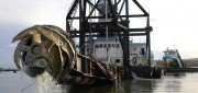
Survey. Dredge. Repeat. Keeping the Columbia River Navigable
December 29, 2014
As the skipper of Galileo 3, a 30-foot sailboat on the Columbia River, I tell my crew that I am comfortable with 15 feet...
December 29, 2014
As the skipper of Galileo 3, a 30-foot sailboat on the Columbia River, I tell my crew that I am comfortable with 15 feet...
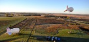
Tethered Aerostats Provide Another Option in the Sky
October 31, 2014
Geospatial professionals are able to choose from an increasingly wide array of platforms on which to deploy ever more accurate...
October 31, 2014
Geospatial professionals are able to choose from an increasingly wide array of platforms on which to deploy ever more accurate...
Mapping People: Human Landscape
August 12, 2014
The executive director of an international nonprofit organization needs to map all the hospitals, clinics, and first aid facilities...
August 12, 2014
The executive director of an international nonprofit organization needs to map all the hospitals, clinics, and first aid facilities...