Satellite imaging
Imagery Options for Esri Users. Esri’s ArcGIS Marketplace
December 29, 2014
IS users increasingly expect content to come with their platform, rather than be an add-on. To help meet this expectation,...
December 29, 2014
IS users increasingly expect content to come with their platform, rather than be an add-on. To help meet this expectation,...
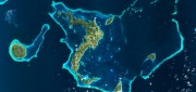
New Markets for Satellite Imagery
October 15, 2014
In June, the U.S. Department of Commerce, granting a request by DigitalGlobe, gave the company permission to sell its imagery...
October 15, 2014
In June, the U.S. Department of Commerce, granting a request by DigitalGlobe, gave the company permission to sell its imagery...

Going Beyond Global Forest Change Modeling Toward Big Earth-system Sustainability
July 7, 2014
One of the more impressive earth observation achievements in recent years was the collaboration between Google and the University...
July 7, 2014
One of the more impressive earth observation achievements in recent years was the collaboration between Google and the University...

Google Earth Outreach Continues Collaborations for Earth Modeling and Monitoring
June 10, 2014
Google Earth is all about putting things in geographic context, aiding literacy and helping users in discovery. This capacity...
June 10, 2014
Google Earth is all about putting things in geographic context, aiding literacy and helping users in discovery. This capacity...
Skybox: First Video from Space
May 31, 2014
AO: What is Skybox Imaging? SKYBOX: Skybox is a data and analysis company that extracts information from satellite imagery....
May 31, 2014
AO: What is Skybox Imaging? SKYBOX: Skybox is a data and analysis company that extracts information from satellite imagery....
Improving Global Carbon Estimates with LiDAR
May 13, 2014
International efforts to mitigate climate change hinge on limiting global anthropogenic CO2 emissions. About 12 percent of these...
May 13, 2014
International efforts to mitigate climate change hinge on limiting global anthropogenic CO2 emissions. About 12 percent of these...

Can Satellites in the Sky Help Prevent Atrocities on Earth?
November 25, 2013
Currently, about a dozen government and commercial Earth-imaging satellites circle the Earth daily. They take thousands of pictures...
November 25, 2013
Currently, about a dozen government and commercial Earth-imaging satellites circle the Earth daily. They take thousands of pictures...

SkyTruth Hopes to Make Skytruthing Into a Verb
October 15, 2013
SkyTruth has a mission to use remote sensing and digital mapping to educate the public and policymakers about the environmental...
October 15, 2013
SkyTruth has a mission to use remote sensing and digital mapping to educate the public and policymakers about the environmental...
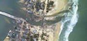
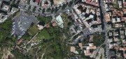
Mapping the Damage from Superstorm Sandy
July 22, 2013
When it hit the United States as a post-tropical cyclone, Sandy had a diameter of 1,100 miles and had been the largest Atlantic...
July 22, 2013
When it hit the United States as a post-tropical cyclone, Sandy had a diameter of 1,100 miles and had been the largest Atlantic...
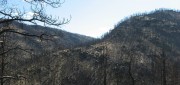
Sensing the Forest for Fuel, Fire, and Recovery
May 6, 2013
Every year, several hundred million hectares of forest, grasslands, and other types of vegetation burn throughout the world,...
May 6, 2013
Every year, several hundred million hectares of forest, grasslands, and other types of vegetation burn throughout the world,...