Item type

Monitoring Polar Changes: Scientists Deploy Many Tools to Measure Sea Ice Thickness
December 29, 2014
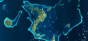
The extent of the polar ice caps is shrinking. This simple fact has been common knowledge since the late 1970s thanks to the added...
December 29, 2014
The extent of the polar ice caps is shrinking. This simple fact has been common knowledge since the late 1970s thanks to the added...
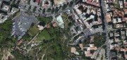
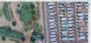
Imagery Options for Esri Users. Esri’s ArcGIS Marketplace
December 29, 2014
IS users increasingly expect content to come with their platform, rather than be an add-on. To help meet this expectation,...
December 29, 2014
IS users increasingly expect content to come with their platform, rather than be an add-on. To help meet this expectation,...

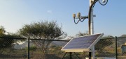
Satellite Signals Steer Farmers Straight
December 29, 2014
Precision agriculture combines GPS, remote sensing, and GIS to capture large amounts of georeferenced data on spatial variations...
December 29, 2014
Precision agriculture combines GPS, remote sensing, and GIS to capture large amounts of georeferenced data on spatial variations...
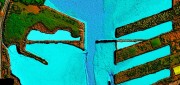
Survey. Dredge. Repeat. Keeping the Columbia River Navigable
December 29, 2014
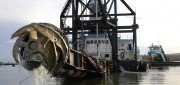
As the skipper of Galileo 3, a 30-foot sailboat on the Columbia River, I tell my crew that I am comfortable with 15 feet...
December 29, 2014
As the skipper of Galileo 3, a 30-foot sailboat on the Columbia River, I tell my crew that I am comfortable with 15 feet...

Tethered Aerostats Provide Another Option in the Sky
October 31, 2014
Geospatial professionals are able to choose from an increasingly wide array of platforms on which to deploy ever more accurate...
October 31, 2014
Geospatial professionals are able to choose from an increasingly wide array of platforms on which to deploy ever more accurate...
From Shore to Floor
October 16, 2014
More than 90% of the world’s trade is carried by sea, according to the International Maritime Organization. Therefore,...
October 16, 2014
More than 90% of the world’s trade is carried by sea, according to the International Maritime Organization. Therefore,...
Mobile System Alerts Dubai Drivers of Approaching Sandstorms
October 16, 2014
Periodically, large sandstorms and low-visibility conditions wreak havoc in the Middle East, with potentially deadly consequences...
October 16, 2014
Periodically, large sandstorms and low-visibility conditions wreak havoc in the Middle East, with potentially deadly consequences...
New Markets for Satellite Imagery
October 15, 2014
In June, the U.S. Department of Commerce, granting a request by DigitalGlobe, gave the company permission to sell its imagery...
October 15, 2014
In June, the U.S. Department of Commerce, granting a request by DigitalGlobe, gave the company permission to sell its imagery...
From Traditional Photogrammetry to UAS
October 15, 2014
Photogrammetry has changed substantially in the past three decades. When Jeff Yates began in the business 32 years ago,...
October 15, 2014
Photogrammetry has changed substantially in the past three decades. When Jeff Yates began in the business 32 years ago,...
Mapping People: Human Landscape
August 12, 2014
The executive director of an international nonprofit organization needs to map all the hospitals, clinics, and first aid facilities...
August 12, 2014
The executive director of an international nonprofit organization needs to map all the hospitals, clinics, and first aid facilities...