Item type

Lidar Innovations: Software Catching Up, Alternative Technologies Emerge
February 24, 2014
Throughout its history, lidar has been one of the very few technologies in which the exponential growth in the hardware’s...
February 24, 2014
Throughout its history, lidar has been one of the very few technologies in which the exponential growth in the hardware’s...

Advocating for Geography Education: Interview with Kirk Goldsberry
December 17, 2013
A recent opinion piece by Kirk Goldsberry, visiting scholar at Harvard University, gained a good deal of attention because...
December 17, 2013
A recent opinion piece by Kirk Goldsberry, visiting scholar at Harvard University, gained a good deal of attention because...
Surveying Cultural Heritage
December 6, 2013
CyArk, a nonprofit organization dedicated to digitally preserving and sharing the world’s cultural heritage, uses laser...
December 6, 2013
CyArk, a nonprofit organization dedicated to digitally preserving and sharing the world’s cultural heritage, uses laser...

Can Satellites in the Sky Help Prevent Atrocities on Earth?
November 25, 2013
Currently, about a dozen government and commercial Earth-imaging satellites circle the Earth daily. They take thousands of pictures...
November 25, 2013
Currently, about a dozen government and commercial Earth-imaging satellites circle the Earth daily. They take thousands of pictures...

SkyTruth Hopes to Make Skytruthing Into a Verb
October 15, 2013
SkyTruth has a mission to use remote sensing and digital mapping to educate the public and policymakers about the environmental...
October 15, 2013
SkyTruth has a mission to use remote sensing and digital mapping to educate the public and policymakers about the environmental...
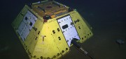
The Abyss, Now Live on Your Desktop
August 5, 2013
The advent of Earth-observation satellites transformed how we view our planet—from occasional snapshots to near continuous,...
August 5, 2013
The advent of Earth-observation satellites transformed how we view our planet—from occasional snapshots to near continuous,...
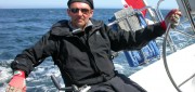
Applying Spatial and Temporal Intelligence to Marine Spatial Planning
August 5, 2013
There's an ongoing need to apply spatial and temporal intelligence to make sense of change. The Pacific Marine Analysis and Research...
August 5, 2013
There's an ongoing need to apply spatial and temporal intelligence to make sense of change. The Pacific Marine Analysis and Research...
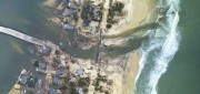
Mapping the Damage from Superstorm Sandy
July 22, 2013
When it hit the United States as a post-tropical cyclone, Sandy had a diameter of 1,100 miles and had been the largest Atlantic...
July 22, 2013
When it hit the United States as a post-tropical cyclone, Sandy had a diameter of 1,100 miles and had been the largest Atlantic...

Measuring Distant Winds: Remote Sensing for Siting Wind Turbines
July 8, 2013
Wind's contribution to energy production in the United States continues to grow. In 2011, it represented a third of all new electric...
July 8, 2013
Wind's contribution to energy production in the United States continues to grow. In 2011, it represented a third of all new electric...
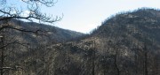
Sensing the Forest for Fuel, Fire, and Recovery
May 6, 2013
Every year, several hundred million hectares of forest, grasslands, and other types of vegetation burn throughout the world,...
May 6, 2013
Every year, several hundred million hectares of forest, grasslands, and other types of vegetation burn throughout the world,...