Feature articles
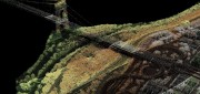
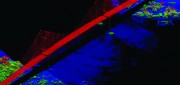
Bathymetric LiDAR: Sandy’s Coastal Impact
February 11, 2013
Detailed and accurate charting of the sea bottom along coastlines is vital for environmental monitoring and remediation,...
February 11, 2013
Detailed and accurate charting of the sea bottom along coastlines is vital for environmental monitoring and remediation,...

Precision Agriculture: Sensors Drive Agricultural Efficiency
January 22, 2013
If Old McDonald had a farm today, he could manage it from his laptop computer and map it with an application on his handheld...
January 22, 2013
If Old McDonald had a farm today, he could manage it from his laptop computer and map it with an application on his handheld...
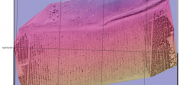
The Oregon Lidar Consortium
January 4, 2013
In less than six years since it was formed, the Oregon Lidar Consortium (OLC) has collected 16 million acres of high-resolution...
January 4, 2013
In less than six years since it was formed, the Oregon Lidar Consortium (OLC) has collected 16 million acres of high-resolution...
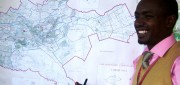
New GIS Promises to Revolutionize Tax Collection in Kenya
October 24, 2012
IN DEVELOPED COUNTRIES, MOST PEOPLE TAKE FOR GRANTED CERTAIN basic public goods, such as clean drinking water, public education...
October 24, 2012
IN DEVELOPED COUNTRIES, MOST PEOPLE TAKE FOR GRANTED CERTAIN basic public goods, such as clean drinking water, public education...
UAS Industry Poised for Explosion
October 24, 2012
Unmanned aerial systems (UAS, formerly called unmanned aerial vehicles), which the U.S. military has routinely used abroad...
October 24, 2012
Unmanned aerial systems (UAS, formerly called unmanned aerial vehicles), which the U.S. military has routinely used abroad...

Sewer Heat Recovery Provides Low-Cost Recycled Energy
October 24, 2012
In every urban area, heat that humans have generated to shower, wash clothes, cook, and so on flows underground — in the sewers,...
October 24, 2012
In every urban area, heat that humans have generated to shower, wash clothes, cook, and so on flows underground — in the sewers,...

Biosensors for Environmental Monitoring
July 31, 2012
The idea for biosensors — using some part of an organism to generate a signal to measure or monitor the presence of a substance...
July 31, 2012
The idea for biosensors — using some part of an organism to generate a signal to measure or monitor the presence of a substance...
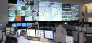
Traffic Data Hits on Real-Time Needs
June 25, 2012
For decades, state and local departments of transportation have collected traffic data by means of a variety of methods — including...
June 25, 2012
For decades, state and local departments of transportation have collected traffic data by means of a variety of methods — including...

Business Uses of Satellite Imagery
June 1, 2012
The public is familiar with satellite imagery through consumer applications — most notably, Google Earth. GeoEye (Herndon,...
June 1, 2012
The public is familiar with satellite imagery through consumer applications — most notably, Google Earth. GeoEye (Herndon,...
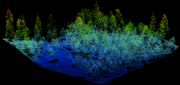
Mapping Carbon in the Forests: Seeing Both the Forest and the Trees
May 8, 2012
Carbon dioxide (CO2) is the most important anthropogenic greenhouse gas. As forests grow, they absorb CO2 from the atmosphere,...
May 8, 2012
Carbon dioxide (CO2) is the most important anthropogenic greenhouse gas. As forests grow, they absorb CO2 from the atmosphere,...