Short articles
Using CartoDB: From creating a map in eight minutes to creating market predictions
May 16, 2016
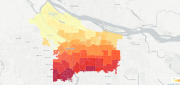
Among the many mapping programs available, CartoDB stands out for its ease of use and sophistication. It allows users to import...
May 16, 2016
Among the many mapping programs available, CartoDB stands out for its ease of use and sophistication. It allows users to import...
Satellite Imagery for Precision Agriculture
March 13, 2016
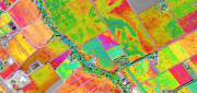
Precision agriculture consists primarily of using geospatial technologies to map spatial variations in crop and soil conditions...
March 13, 2016
Precision agriculture consists primarily of using geospatial technologies to map spatial variations in crop and soil conditions...
ADVANCING GNSS: A profile of Septentrio
March 7, 2016
Septentrio makes high-precision GNSS receivers for commercial and scientific applications. Its origins are in European space...
March 7, 2016
Septentrio makes high-precision GNSS receivers for commercial and scientific applications. Its origins are in European space...

123D Catch for the Masses
November 11, 2015
Stereoscopic imaging, better known as 3D, is not new. In the 16th century, “binocular” images were viewed cross-eyed....
November 11, 2015
Stereoscopic imaging, better known as 3D, is not new. In the 16th century, “binocular” images were viewed cross-eyed....
Navigating Without Addresses
April 10, 2015
New codes aim to bring billions of people into the geospatial market When we mail a letter to an address in an industrialized...
April 10, 2015
New codes aim to bring billions of people into the geospatial market When we mail a letter to an address in an industrialized...

Tracking Aircraft in Flight
April 10, 2015
The disappearance of Malaysia Airlines Flight 370 on March 8, 2014, with 239 people on board, was both tragic and stunning....
April 10, 2015
The disappearance of Malaysia Airlines Flight 370 on March 8, 2014, with 239 people on board, was both tragic and stunning....

Satellite Signals Steer Farmers Straight
December 29, 2014
Precision agriculture combines GPS, remote sensing, and GIS to capture large amounts of georeferenced data on spatial variations...
December 29, 2014
Precision agriculture combines GPS, remote sensing, and GIS to capture large amounts of georeferenced data on spatial variations...
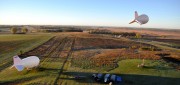
Tethered Aerostats Provide Another Option in the Sky
October 31, 2014
Geospatial professionals are able to choose from an increasingly wide array of platforms on which to deploy ever more accurate...
October 31, 2014
Geospatial professionals are able to choose from an increasingly wide array of platforms on which to deploy ever more accurate...
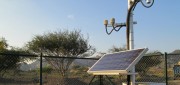
Mobile System Alerts Dubai Drivers of Approaching Sandstorms
October 16, 2014
Periodically, large sandstorms and low-visibility conditions wreak havoc in the Middle East, with potentially deadly consequences...
October 16, 2014
Periodically, large sandstorms and low-visibility conditions wreak havoc in the Middle East, with potentially deadly consequences...
New Markets for Satellite Imagery
October 15, 2014
In June, the U.S. Department of Commerce, granting a request by DigitalGlobe, gave the company permission to sell its imagery...
October 15, 2014
In June, the U.S. Department of Commerce, granting a request by DigitalGlobe, gave the company permission to sell its imagery...