Geographic information systems
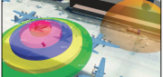
CLIVE: Communicating Risk in 3D
February 21, 2017
Static 3D models of topography and buildings are commonplace in both technical and popular geospatial software. There are still...
February 21, 2017
Static 3D models of topography and buildings are commonplace in both technical and popular geospatial software. There are still...

From Selling Pixels to Selling Answers
February 21, 2017
This series of articles began in our Fall 2015 issue by focusing on the impact on vendors and users of geospatial technologies...
February 21, 2017
This series of articles began in our Fall 2015 issue by focusing on the impact on vendors and users of geospatial technologies...
Automating the Mundane
January 19, 2017
You don’t have to work for huge organizations, such as the U.S. Air Force or the U.S. Forest Service, to appreciate the benefits...
January 19, 2017
You don’t have to work for huge organizations, such as the U.S. Air Force or the U.S. Forest Service, to appreciate the benefits...
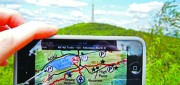
Custom, Portable Maps — Via App!
December 12, 2016
Avenza has evolved its map products into an app that lets people upload their own map—or download a map of their choice—to...
December 12, 2016
Avenza has evolved its map products into an app that lets people upload their own map—or download a map of their choice—to...

3D Software, Not Really Like CAD at All
December 1, 2016
Editor’s note: For many firms and practitioners of surveying, photogrammetry, mapping, and remote sensing, traditional...
December 1, 2016
Editor’s note: For many firms and practitioners of surveying, photogrammetry, mapping, and remote sensing, traditional...

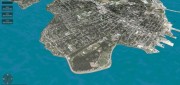
Geospatial Solutions: from PIXIA, Luciad, and BAE Systems
October 10, 2016
This series began a year ago by examining alternatives to Google Earth Enterprise, which Google will stop supporting on March...
October 10, 2016
This series began a year ago by examining alternatives to Google Earth Enterprise, which Google will stop supporting on March...
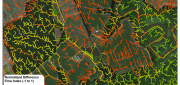
LiDAR, GIS and the Chesapeake Conservancy: Precision Conservation
June 2, 2016
Building on the practice of precision agriculture and exploiting recent computer advances, the Chesapeake Conservancy (CC)...
June 2, 2016
Building on the practice of precision agriculture and exploiting recent computer advances, the Chesapeake Conservancy (CC)...
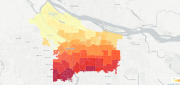
Using CartoDB: From creating a map in eight minutes to creating market predictions
May 16, 2016
Among the many mapping programs available, CartoDB stands out for its ease of use and sophistication. It allows users to import...
May 16, 2016
Among the many mapping programs available, CartoDB stands out for its ease of use and sophistication. It allows users to import...
Companies Pick Up Where Google Earth Enterprise Leaves off
May 16, 2016
The waves created by Google’s announcement that it will stop supporting Google Earth Enterprise (GEE) in the spring of 2017...
May 16, 2016
The waves created by Google’s announcement that it will stop supporting Google Earth Enterprise (GEE) in the spring of 2017...

Data Management & Visualization: Married Or Separated?
March 21, 2016
Large users of geospatial data are searching for alternatives to Google Earth Enterprise (GEE), which Google will discontinue...
March 21, 2016
Large users of geospatial data are searching for alternatives to Google Earth Enterprise (GEE), which Google will discontinue...