Geographic information systems

Google Earth Outreach Continues Collaborations for Earth Modeling and Monitoring
June 10, 2014
Google Earth is all about putting things in geographic context, aiding literacy and helping users in discovery. This capacity...
June 10, 2014
Google Earth is all about putting things in geographic context, aiding literacy and helping users in discovery. This capacity...
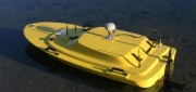
Hydrography by Remote
May 6, 2014
Before they even start taking measurements, surveyors often have to deal with such practical challenges as how to access...
May 6, 2014
Before they even start taking measurements, surveyors often have to deal with such practical challenges as how to access...
Surveying Cultural Heritage
December 6, 2013
CyArk, a nonprofit organization dedicated to digitally preserving and sharing the world’s cultural heritage, uses laser...
December 6, 2013
CyArk, a nonprofit organization dedicated to digitally preserving and sharing the world’s cultural heritage, uses laser...

Applying Spatial and Temporal Intelligence to Marine Spatial Planning
August 5, 2013
There's an ongoing need to apply spatial and temporal intelligence to make sense of change. The Pacific Marine Analysis and Research...
August 5, 2013
There's an ongoing need to apply spatial and temporal intelligence to make sense of change. The Pacific Marine Analysis and Research...
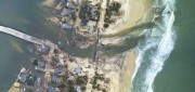
Mapping the Damage from Superstorm Sandy
July 22, 2013
When it hit the United States as a post-tropical cyclone, Sandy had a diameter of 1,100 miles and had been the largest Atlantic...
July 22, 2013
When it hit the United States as a post-tropical cyclone, Sandy had a diameter of 1,100 miles and had been the largest Atlantic...
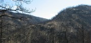
Sensing the Forest for Fuel, Fire, and Recovery
May 6, 2013
Every year, several hundred million hectares of forest, grasslands, and other types of vegetation burn throughout the world,...
May 6, 2013
Every year, several hundred million hectares of forest, grasslands, and other types of vegetation burn throughout the world,...
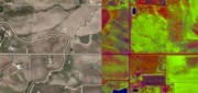
What and Where: The Integration of Remote Sensing and GIS
March 5, 2013
The sciences, technologies, and practices of remote sensing and of geographic information systems (GIS), arose separately,...
March 5, 2013
The sciences, technologies, and practices of remote sensing and of geographic information systems (GIS), arose separately,...

Russ Johnson: Painting a Geographical Picture of Complex Emergencies
January 14, 2013
GIS has long been used to get a handle on complex emergency situations as maps provide a means for a common understanding...
January 14, 2013
GIS has long been used to get a handle on complex emergency situations as maps provide a means for a common understanding...
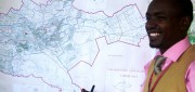
New GIS Promises to Revolutionize Tax Collection in Kenya
October 24, 2012
IN DEVELOPED COUNTRIES, MOST PEOPLE TAKE FOR GRANTED CERTAIN basic public goods, such as clean drinking water, public education...
October 24, 2012
IN DEVELOPED COUNTRIES, MOST PEOPLE TAKE FOR GRANTED CERTAIN basic public goods, such as clean drinking water, public education...
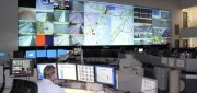
Traffic Data Hits on Real-Time Needs
June 25, 2012
For decades, state and local departments of transportation have collected traffic data by means of a variety of methods — including...
June 25, 2012
For decades, state and local departments of transportation have collected traffic data by means of a variety of methods — including...