Sensors & Systems
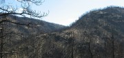
Sensing the Forest for Fuel, Fire, and Recovery
May 6, 2013
Every year, several hundred million hectares of forest, grasslands, and other types of vegetation burn throughout the world,...
May 6, 2013
Every year, several hundred million hectares of forest, grasslands, and other types of vegetation burn throughout the world,...

Spreading the Inspiration of Earth Observation
April 8, 2013
Research scientists continue to add to our understanding of Earth systems, thanks to the global Earth observation capacity....
April 8, 2013
Research scientists continue to add to our understanding of Earth systems, thanks to the global Earth observation capacity....

exactEarth Provides Unique Insight Into Global Ocean Traffic
March 11, 2013
exactEarth has successfully launched an earth observation satellite constellation to track Automated Identification System...
March 11, 2013
exactEarth has successfully launched an earth observation satellite constellation to track Automated Identification System...
What and Where: The Integration of Remote Sensing and GIS
March 5, 2013
The sciences, technologies, and practices of remote sensing and of geographic information systems (GIS), arose separately,...
March 5, 2013
The sciences, technologies, and practices of remote sensing and of geographic information systems (GIS), arose separately,...

Russ Johnson: Painting a Geographical Picture of Complex Emergencies
January 14, 2013
GIS has long been used to get a handle on complex emergency situations as maps provide a means for a common understanding...
January 14, 2013
GIS has long been used to get a handle on complex emergency situations as maps provide a means for a common understanding...

Mike Martinez: Trimble Continues to Innovate to Meet Growing Agriculture Demands
January 7, 2013
The application of GNSS sensors and machine control to agriculture, with a prescriptive approach that matches maps of the field...
January 7, 2013
The application of GNSS sensors and machine control to agriculture, with a prescriptive approach that matches maps of the field...

Jenn Sabers: Landsat Poised to Meet Scientific Mission
November 26, 2012
The Landsat Data Continuity Mission, a joint project between NASA and the U.S. Geological Survey, is poised to deliver better...
November 26, 2012
The Landsat Data Continuity Mission, a joint project between NASA and the U.S. Geological Survey, is poised to deliver better...

Walter Scott: Analytics and Monitoring Drive DigitalGlobe Growth
November 19, 2012
DigitalGlobe has had amazing stock performance of greater than 22 percent growth over the past five years and nearly 30 percent...
November 19, 2012
DigitalGlobe has had amazing stock performance of greater than 22 percent growth over the past five years and nearly 30 percent...

Mark Romano: Earth Eye Makes Inroads in Sensor Fusion
November 5, 2012
Earth Eye is a relatively new company that has been focused on LiDAR data capture, and the fusion of LiDAR with other sensor...
November 5, 2012
Earth Eye is a relatively new company that has been focused on LiDAR data capture, and the fusion of LiDAR with other sensor...

Shoshanna Budzianowski: Eye on Earth: Microsoft Continues Investment in Network
August 21, 2012
THE EYE ON EARTH (EOE) NETWORK has garnered a great deal of praise for providing European environmental data openly and transparently,...
August 21, 2012
THE EYE ON EARTH (EOE) NETWORK has garnered a great deal of praise for providing European environmental data openly and transparently,...