Sensors & Systems
Biosensors for Environmental Monitoring
July 31, 2012
The idea for biosensors — using some part of an organism to generate a signal to measure or monitor the presence of a substance...
July 31, 2012
The idea for biosensors — using some part of an organism to generate a signal to measure or monitor the presence of a substance...
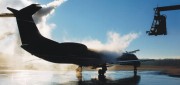
Traffic Data Hits on Real-Time Needs
June 25, 2012
For decades, state and local departments of transportation have collected traffic data by means of a variety of methods — including...
June 25, 2012
For decades, state and local departments of transportation have collected traffic data by means of a variety of methods — including...

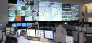
Wade Larson and George Tyc: UrtheCast Promises a Live Video Feed of Earth from Space
June 12, 2012
UrtheCast is a company created to provide the first live high-definition video feed of Earth from space. Working jointly...
June 12, 2012
UrtheCast is a company created to provide the first live high-definition video feed of Earth from space. Working jointly...
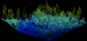
Mapping Carbon in the Forests: Seeing Both the Forest and the Trees
May 8, 2012
Carbon dioxide (CO2) is the most important anthropogenic greenhouse gas. As forests grow, they absorb CO2 from the atmosphere,...
May 8, 2012
Carbon dioxide (CO2) is the most important anthropogenic greenhouse gas. As forests grow, they absorb CO2 from the atmosphere,...
Stephen R.J. Sheppard: Collaborative Visualization to Advance Landscape Planning
April 15, 2012
Recently the University of British Columbia unveiled The Decision Theatre, an interactive and immersive computer visualization...
April 15, 2012
Recently the University of British Columbia unveiled The Decision Theatre, an interactive and immersive computer visualization...