• Home
  • About
    • About PBD
    • What Are Geospatial Technologies?
    • Matteo Luccio’s Bio
    • Conferences
    • Our Name
  • Topics
    • 3D imaging
    • Aerial photography
    • Bathymetry
    • Building Information Modeling (BIM)
    • CAD
    • Energy
    • Cadaster
    • Environment
    • Geodesy
    • GIS
    • LiDAR
    • Mapping
    • Navigation
    • Open source software
    • Other
    • Photogrammetry
    • Precision agriculture
    • Radar
    • Remote sensing
    • Satellite imaging
    • Satellite navigation
    • Seismology
    • Sensors
    • Surveying
    • UAS
    • Tracking
  • Magazines
    • Apogeo Spatial
    • ArcNews
    • ArcWatch
    • CE News
    • Earth Imaging Journal
    • GEOInformatics
    • GeoWorld
    • GIM International
    • Heights
    • Informed Infrastruct.
    • Imaging Notes
    • Point of Beginning
    • Prof. Surveyor Mag.
    • Sensors & Systems
    • Septentrio Insights
    • The American Surveyor
    • xyHt
  • Formats
    • Feature articles
    • Short articles
    • Interviews
    • News items
    • Other
  • All
  • Clients
  • Tips
    • Gripes
    • Tips
  • Contact Us
 

LiDAR Update: Terrestrial Explodes, Software Still Lags

Posted by: Matteo    Tags:      Posted date:  January 25, 2011  |  No comment


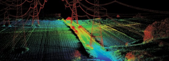
Looking at the image of the underside of a bridge derived from data collected by a boat-mounted LiDAR system, engineers can detect spalling, a type of deterioration in concrete. Surveyors can collect data at a few centimeter accuracy while driving in traffic with a LiDAR system mounted on their truck, at much less risk than by standing with a tripod on the side of a busy freeway, where sub-centimeter is achievable. By scanning facades with LiDAR and fusing this data with aerial digital imagery, companies are creating detailed 3D building models that will soon be commonplace in digital maps on smart phones and car navigation systems. These are just a few of the rapidly increasing number of applications made possible by continuing improvements in LiDAR technology. “LiDAR systems are getting more sophisticated and standardized. The American Society for Photogrammetry and Remote Sensing (ASPRS) is considering a proposal to establish a LiDAR division,” says Jim Van Rens, President of Riegl USA.

Read more…


Want to say something?


  Cancel Reply


− 3 = four

« STI’s Two Recent Projects: Aerial Surveying at Airports
Google Earth Builder: Advantages for Businesses »


Copyright (c) 2012 by Pale Blue Dot, LLC / For information write to matteo@palebluedotllc.com