• Home
  • About
    • About PBD
    • What Are Geospatial Technologies?
    • Matteo Luccio’s Bio
    • Conferences
    • Our Name
  • Topics
    • 3D imaging
    • Aerial photography
    • Bathymetry
    • Building Information Modeling (BIM)
    • CAD
    • Energy
    • Cadaster
    • Environment
    • Geodesy
    • GIS
    • LiDAR
    • Mapping
    • Navigation
    • Open source software
    • Other
    • Photogrammetry
    • Precision agriculture
    • Radar
    • Remote sensing
    • Satellite imaging
    • Satellite navigation
    • Seismology
    • Sensors
    • Surveying
    • UAS
    • Tracking
  • Magazines
    • Apogeo Spatial
    • ArcNews
    • ArcWatch
    • CE News
    • Earth Imaging Journal
    • GEOInformatics
    • GeoWorld
    • GIM International
    • Heights
    • Informed Infrastruct.
    • Imaging Notes
    • Point of Beginning
    • Prof. Surveyor Mag.
    • Sensors & Systems
    • Septentrio Insights
    • The American Surveyor
    • xyHt
  • Formats
    • Feature articles
    • Short articles
    • Interviews
    • News items
    • Other
  • All
  • Clients
  • Tips
    • Gripes
    • Tips
  • Contact Us
 

Helping Haiti: Disaster-Response Lab Manages Aerial Data for Earthquake Relief

Posted by: Matteo    Tags:      Posted date:  October 1, 2010  |  No comment


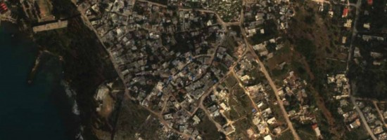
In the immediate aftermath of the devastating earthquake that hit Haiti on 2010 January 12, taking the lives of more than 200,000 people and displacing more than one million others from their homes, one of the most vital emergency-response tasks was to quickly and efficiently assess the conditions of tens of thousands of damaged buildings to determine which could still be safely occupied.

As the disaster unfolded and assessments were underway, it became evident that there also was a need for assistance in high-resolution imaging, light detection and ranging (LiDAR) data, and maps for a variety of other rescue and reconstruction tasks (e.g., debris quantification, hydrological mapping, and fault line assessment.)

Read more…


Want to say something?


  Cancel Reply


seven − = 6

« Aerial Cameras: Focus Shifts to Productivity
STI’s Two Recent Projects: Aerial Surveying at Airports »


Copyright (c) 2012 by Pale Blue Dot, LLC / For information write to matteo@palebluedotllc.com