• Home
  • About
    • About PBD
    • What Are Geospatial Technologies?
    • Matteo Luccio’s Bio
    • Conferences
    • Our Name
  • Topics
    • 3D imaging
    • Aerial photography
    • Bathymetry
    • Building Information Modeling (BIM)
    • CAD
    • Energy
    • Cadaster
    • Environment
    • Geodesy
    • GIS
    • LiDAR
    • Mapping
    • Navigation
    • Open source software
    • Other
    • Photogrammetry
    • Precision agriculture
    • Radar
    • Remote sensing
    • Satellite imaging
    • Satellite navigation
    • Seismology
    • Sensors
    • Surveying
    • UAS
    • Tracking
  • Magazines
    • Apogeo Spatial
    • ArcNews
    • ArcWatch
    • CE News
    • Earth Imaging Journal
    • GEOInformatics
    • GeoWorld
    • GIM International
    • Heights
    • Informed Infrastruct.
    • Imaging Notes
    • Point of Beginning
    • Prof. Surveyor Mag.
    • Sensors & Systems
    • Septentrio Insights
    • The American Surveyor
    • xyHt
  • Formats
    • Feature articles
    • Short articles
    • Interviews
    • News items
    • Other
  • All
  • Clients
  • Tips
    • Gripes
    • Tips
  • Contact Us
 

Mapping Application Makes Accurate Data Available in Real Time: Mobile GIS Helps Firefighters Respond More Effectively

Posted by: Matteo    Tags:      Posted date:  June 1, 2010  |  No comment


For nearly a decade, the City of Marietta Fire Department in Georgia made do with a mapping application that was difficult to use and often displayed outdated information. Meanwhile, the city’s GIS division had up-to-date data but no good way to make it available in real time to emergency responders.

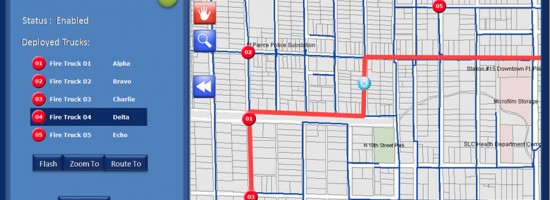
Now the department operates with a state-of-the-art mobile mapping application that can route and re-route fire trucks on-the-fly. The application operator can even steer firefighters to entry points, hallways, and stairs in a mapped building that may be hidden behind thick smoke but are clearly visible on the computer screen.

Recently the city’s IT department and fire department, working as partners, reviewed options for making better use of the city’s existing data and infrastructure and upgrading its fire mobility application. The city contracted with Geographic Information Services, Inc. (GISi), an Esri business partner, to design and implement a new server-based application.

Read more…


Want to say something?


  Cancel Reply


− three = 2

« RADAR Gets It Done
Aerial Cameras: Focus Shifts to Productivity »


Copyright (c) 2012 by Pale Blue Dot, LLC / For information write to matteo@palebluedotllc.com