Geospatial topics

Trimble UAS Answers Tall Task
November 9, 2015
In the steep canyons of the Republic of Macedonia — a landlocked Balkan nation of mountains, lakes and ancient towns — international...
November 9, 2015
In the steep canyons of the Republic of Macedonia — a landlocked Balkan nation of mountains, lakes and ancient towns — international...
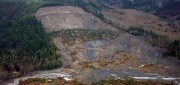
See the Light: LiDAR Data Help Expose Landslide Hazards
October 12, 2015
On March 22, 2014, four miles east of Oso, Wash., a portion of an unstable hill collapsed, sending mud and debris across...
October 12, 2015
On March 22, 2014, four miles east of Oso, Wash., a portion of an unstable hill collapsed, sending mud and debris across...
The Urgency of Building Bridges Between EO & Satcom
August 12, 2015
Currently, billions of individuals in every major world region— and billions of dollars worth of commerce—are supported...
August 12, 2015
Currently, billions of individuals in every major world region— and billions of dollars worth of commerce—are supported...

Moving Forward with UAS Mapping
June 16, 2015
For geospatial professionals, the most exciting aspect of the current explosion in unmanned aircraft systems (UASs) is using...
June 16, 2015
For geospatial professionals, the most exciting aspect of the current explosion in unmanned aircraft systems (UASs) is using...

Mapping the Appalachian Trail (Part 1 of 2)
May 26, 2015
How the AT was created and surveyed, from Avery’s wheel to GPS The Appalachian Trail (AT) is very old, very long, and iconic....
May 26, 2015
How the AT was created and surveyed, from Avery’s wheel to GPS The Appalachian Trail (AT) is very old, very long, and iconic....

Navigating Without Addresses
April 10, 2015
New codes aim to bring billions of people into the geospatial market When we mail a letter to an address in an industrialized...
April 10, 2015
New codes aim to bring billions of people into the geospatial market When we mail a letter to an address in an industrialized...

Satellite Imagery’s Impact
April 10, 2015
Unthreatened, aerial imaging/mapping companies embrace commercial satellite imagery's increased resolution Last June,...
April 10, 2015
Unthreatened, aerial imaging/mapping companies embrace commercial satellite imagery's increased resolution Last June,...

Tracking Aircraft in Flight
April 10, 2015
The disappearance of Malaysia Airlines Flight 370 on March 8, 2014, with 239 people on board, was both tragic and stunning....
April 10, 2015
The disappearance of Malaysia Airlines Flight 370 on March 8, 2014, with 239 people on board, was both tragic and stunning....

Maximizing the Sun: Solar energy grows in part due to aerial imaging and surveying
April 10, 2015
Solar power is booming in the United States. “Every three weeks,” President Obama said in his 2015 State of the Union...
April 10, 2015
Solar power is booming in the United States. “Every three weeks,” President Obama said in his 2015 State of the Union...
Sensor Fusion: Deriving Information from Data
April 9, 2015
The current explosion in the variety, capability and sheer number of sensors is generating a flood of data intended to enhance...
April 9, 2015
The current explosion in the variety, capability and sheer number of sensors is generating a flood of data intended to enhance...