Geospatial topics
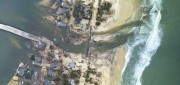
Mapping the Damage from Superstorm Sandy
July 22, 2013
When it hit the United States as a post-tropical cyclone, Sandy had a diameter of 1,100 miles and had been the largest Atlantic...
July 22, 2013
When it hit the United States as a post-tropical cyclone, Sandy had a diameter of 1,100 miles and had been the largest Atlantic...

Measuring Distant Winds: Remote Sensing for Siting Wind Turbines
July 8, 2013
Wind's contribution to energy production in the United States continues to grow. In 2011, it represented a third of all new electric...
July 8, 2013
Wind's contribution to energy production in the United States continues to grow. In 2011, it represented a third of all new electric...
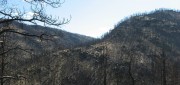
Sensing the Forest for Fuel, Fire, and Recovery
May 6, 2013
Every year, several hundred million hectares of forest, grasslands, and other types of vegetation burn throughout the world,...
May 6, 2013
Every year, several hundred million hectares of forest, grasslands, and other types of vegetation burn throughout the world,...

Spreading the Inspiration of Earth Observation
April 8, 2013
Research scientists continue to add to our understanding of Earth systems, thanks to the global Earth observation capacity....
April 8, 2013
Research scientists continue to add to our understanding of Earth systems, thanks to the global Earth observation capacity....

exactEarth Provides Unique Insight Into Global Ocean Traffic
March 11, 2013
exactEarth has successfully launched an earth observation satellite constellation to track Automated Identification System...
March 11, 2013
exactEarth has successfully launched an earth observation satellite constellation to track Automated Identification System...
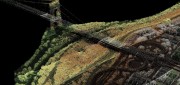
What and Where: The Integration of Remote Sensing and GIS
March 5, 2013
The sciences, technologies, and practices of remote sensing and of geographic information systems (GIS), arose separately,...
March 5, 2013
The sciences, technologies, and practices of remote sensing and of geographic information systems (GIS), arose separately,...
Bathymetric LiDAR: Sandy’s Coastal Impact
February 11, 2013
Detailed and accurate charting of the sea bottom along coastlines is vital for environmental monitoring and remediation,...
February 11, 2013
Detailed and accurate charting of the sea bottom along coastlines is vital for environmental monitoring and remediation,...

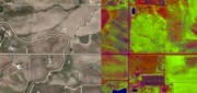
Precision Agriculture: Sensors Drive Agricultural Efficiency
January 22, 2013
If Old McDonald had a farm today, he could manage it from his laptop computer and map it with an application on his handheld...
January 22, 2013
If Old McDonald had a farm today, he could manage it from his laptop computer and map it with an application on his handheld...

Russ Johnson: Painting a Geographical Picture of Complex Emergencies
January 14, 2013
GIS has long been used to get a handle on complex emergency situations as maps provide a means for a common understanding...
January 14, 2013
GIS has long been used to get a handle on complex emergency situations as maps provide a means for a common understanding...

Mike Martinez: Trimble Continues to Innovate to Meet Growing Agriculture Demands
January 7, 2013
The application of GNSS sensors and machine control to agriculture, with a prescriptive approach that matches maps of the field...
January 7, 2013
The application of GNSS sensors and machine control to agriculture, with a prescriptive approach that matches maps of the field...