Mapping and cartography
Sensing the Forest for Fuel, Fire, and Recovery
May 6, 2013
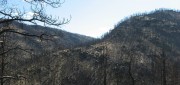
Every year, several hundred million hectares of forest, grasslands, and other types of vegetation burn throughout the world,...
May 6, 2013
Every year, several hundred million hectares of forest, grasslands, and other types of vegetation burn throughout the world,...
New GIS Promises to Revolutionize Tax Collection in Kenya
October 24, 2012
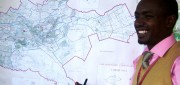
IN DEVELOPED COUNTRIES, MOST PEOPLE TAKE FOR GRANTED CERTAIN basic public goods, such as clean drinking water, public education...
October 24, 2012
IN DEVELOPED COUNTRIES, MOST PEOPLE TAKE FOR GRANTED CERTAIN basic public goods, such as clean drinking water, public education...

Shoshanna Budzianowski: Eye on Earth: Microsoft Continues Investment in Network
August 21, 2012
THE EYE ON EARTH (EOE) NETWORK has garnered a great deal of praise for providing European environmental data openly and transparently,...
August 21, 2012
THE EYE ON EARTH (EOE) NETWORK has garnered a great deal of praise for providing European environmental data openly and transparently,...
Mapping Carbon in the Forests: Seeing Both the Forest and the Trees
May 8, 2012
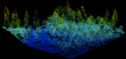
Carbon dioxide (CO2) is the most important anthropogenic greenhouse gas. As forests grow, they absorb CO2 from the atmosphere,...
May 8, 2012
Carbon dioxide (CO2) is the most important anthropogenic greenhouse gas. As forests grow, they absorb CO2 from the atmosphere,...
Google Earth Builder: Productizing Server Farms for Storing and Processing Geospatial Data
March 24, 2012
Google Earth Builder (GEB), which Google released last fall, enables private companies and government agencies to store and process...
March 24, 2012
Google Earth Builder (GEB), which Google released last fall, enables private companies and government agencies to store and process...
Google Earth Builder: Advantages for Businesses
June 1, 2011
Google Earth, launched six years ago, expanded by orders of magnitude the market for geospatial technologies. The initial...
June 1, 2011
Google Earth, launched six years ago, expanded by orders of magnitude the market for geospatial technologies. The initial...
Rapid Response Mapping at Sanborn: Mapping Against the Clock
April 1, 2010
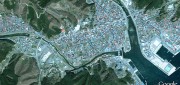
Early one morning in December 2005, the Taum Sauk Hydroelectric Plant Upper Reservoir, in the Missouri Ozarks, failed catastrophically,...
April 1, 2010
Early one morning in December 2005, the Taum Sauk Hydroelectric Plant Upper Reservoir, in the Missouri Ozarks, failed catastrophically,...