Item type

Stephen R.J. Sheppard: Collaborative Visualization to Advance Landscape Planning
April 15, 2012
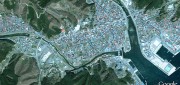
Recently the University of British Columbia unveiled The Decision Theatre, an interactive and immersive computer visualization...
April 15, 2012
Recently the University of British Columbia unveiled The Decision Theatre, an interactive and immersive computer visualization...

Share Engineering Benefits of Geospatial Technologies
April 10, 2012
Civil engineers have been routinely using geospatial technologies for decades. Now they should write short case studies explaining...
April 10, 2012
Civil engineers have been routinely using geospatial technologies for decades. Now they should write short case studies explaining...
Google Earth Builder: Productizing Server Farms for Storing and Processing Geospatial Data
March 24, 2012
Google Earth Builder (GEB), which Google released last fall, enables private companies and government agencies to store and process...
March 24, 2012
Google Earth Builder (GEB), which Google released last fall, enables private companies and government agencies to store and process...
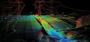
LiDAR Software Update: Companies Respond to Customer Demands
February 25, 2012
The market for software to manage, process, fuse, and visualize LiDAR point cloud data is still very young and amorphous....
February 25, 2012
The market for software to manage, process, fuse, and visualize LiDAR point cloud data is still very young and amorphous....

Radar Update: Applications Abound in Defense, Maritime and Engineering
October 25, 2011
Whether used to view Earth’s surface through clouds or at night, to measure the thickness of polar ice sheets, to map long-abandoned...
October 25, 2011
Whether used to view Earth’s surface through clouds or at night, to measure the thickness of polar ice sheets, to map long-abandoned...
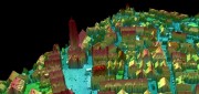
Processing Point Clouds: 3D Data Update
October 25, 2011
Like raster and vector data many years ago, 3D clouds of billions of LiDAR points — which can be colored and very realistic...
October 25, 2011
Like raster and vector data many years ago, 3D clouds of billions of LiDAR points — which can be colored and very realistic...

Global Ortho Project: Continuous, Consistent and Current Coverage
July 1, 2011
Microsoft’s Global Ortho (GO) project aims to capture the entire continental United States and Western Europe at a spatial...
July 1, 2011
Microsoft’s Global Ortho (GO) project aims to capture the entire continental United States and Western Europe at a spatial...
Google Earth Builder: Advantages for Businesses
June 1, 2011
Google Earth, launched six years ago, expanded by orders of magnitude the market for geospatial technologies. The initial...
June 1, 2011
Google Earth, launched six years ago, expanded by orders of magnitude the market for geospatial technologies. The initial...
LiDAR Update: Terrestrial Explodes, Software Still Lags
January 25, 2011
Looking at the image of the underside of a bridge derived from data collected by a boat-mounted LiDAR system, engineers can detect...
January 25, 2011
Looking at the image of the underside of a bridge derived from data collected by a boat-mounted LiDAR system, engineers can detect...

STI’s Two Recent Projects: Aerial Surveying at Airports
January 14, 2011
Société Topographie Informatique (STI) -- based in Evry, near Paris, France -- specializes in topography, photogrammetry,...
January 14, 2011
Société Topographie Informatique (STI) -- based in Evry, near Paris, France -- specializes in topography, photogrammetry,...