Feature articles
Street Views of the Water
November 6, 2018
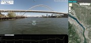
Mapping rivers above and below the surface creates great opportunity for engineers and stewards. The way maps are produced...
November 6, 2018
Mapping rivers above and below the surface creates great opportunity for engineers and stewards. The way maps are produced...
After the Storm
November 6, 2018
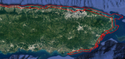
Post-hurricane coastal mapping is a complex process made easier with airborne bathymetry. Lately, large storms such as hurricanes,...
November 6, 2018
Post-hurricane coastal mapping is a complex process made easier with airborne bathymetry. Lately, large storms such as hurricanes,...

mESRIsoft
November 6, 2018
More than partners, Esri and Microsoft collaborate and combine platforms to benefit their users and the public. From their...
November 6, 2018
More than partners, Esri and Microsoft collaborate and combine platforms to benefit their users and the public. From their...

Not Everything Requires High Accuracies
November 6, 2018
How feature inspection, assessment, and reporting are now available to non-experts (and experts alike). In the early 2000s,...
November 6, 2018
How feature inspection, assessment, and reporting are now available to non-experts (and experts alike). In the early 2000s,...

Where the Data Comes From
November 6, 2018
Members of Esri’s Living Atlas unit detail the company’s wide variety of data sources. For nearly 50 years, Esri has been...
November 6, 2018
Members of Esri’s Living Atlas unit detail the company’s wide variety of data sources. For nearly 50 years, Esri has been...

Freeing the Data
November 6, 2018
A Canadian software company is making it easy for the geospatial community (and beyond) to work with, exchange, and extract...
November 6, 2018
A Canadian software company is making it easy for the geospatial community (and beyond) to work with, exchange, and extract...

Radiant.Earth
November 6, 2018
Nonprofits working on global development issues have had great difficulty acquiring and using a staple source of geospatial...
November 6, 2018
Nonprofits working on global development issues have had great difficulty acquiring and using a staple source of geospatial...
Companies Apply Machine Learning for Ag
March 6, 2018
The shift in the Earth observation (EO) market from selling pixels to selling finished intelligence products has sharply...
March 6, 2018
The shift in the Earth observation (EO) market from selling pixels to selling finished intelligence products has sharply...
Easing the 3D Workflow
February 19, 2018
For 30 years, an Alaska-based company has been producing digital mapping and photogrammetic software to help automate the complex...
February 19, 2018
For 30 years, an Alaska-based company has been producing digital mapping and photogrammetic software to help automate the complex...
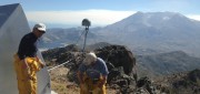
Shifting Ground: GNSS for Earthquakes
February 19, 2018
This is the third article in a series in xyHt introducing readers to scientists and technologists who work in pursuit of early-warning...
February 19, 2018
This is the third article in a series in xyHt introducing readers to scientists and technologists who work in pursuit of early-warning...